Category:Maps of Riverside, Buffalo, New York
Jump to navigation
Jump to search
Media in category "Maps of Riverside, Buffalo, New York"
The following 3 files are in this category, out of 3 total.
-
 Buffalo, Double Page Plate No. 24 (Map bounded by Grove St., Cass St., N. Elmwood Ave., Amherst St., Niagara River) NYPL2055440.tiff 7,096 × 5,322, 2 pages; 108.31 MB
-
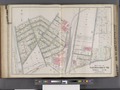
 Buffalo, V. 1, Double Page Plate No.4 (Map bounded by O'neil St., Kenmore Ave., Crowley Ave., Niagara River) NYPL2056887.tiff 7,109 × 5,331, 2 pages; 108.69 MB
-