Category:Maps of Riggs Glacier
Jump to navigation
Jump to search
Media in category "Maps of Riggs Glacier"
The following 5 files are in this category, out of 5 total.
-
 Glacier Bay National Park NPS map of glacial ice extent in 1794.jpg 2,988 × 5,312; 1.99 MB
-
 Glacier Bay National Park NPS map of glacial ice extent in 1879.jpg 2,988 × 5,312; 1.89 MB
-
 Glacier Bay National Park official park brochure map.jpg 2,020 × 1,222; 1.51 MB
-
 Glacier National Park NPS map of glacial ice extent in 1980.jpg 2,988 × 5,312; 2.07 MB
-
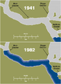 Muir Glacier retreat.png 602 × 820; 144 KB


