Category:Maps of Reynès
Jump to navigation
Jump to search
Wikimedia category | |||||
| Upload media | |||||
| Instance of | |||||
|---|---|---|---|---|---|
| Category combines topics | |||||
| Reynès | |||||
commune in Pyrénées-Orientales, France   | |||||
| Pronunciation audio | |||||
| Instance of | |||||
| Location | |||||
| Located in or next to body of water | |||||
| Street address |
| ||||
| Head of government |
| ||||
| Population |
| ||||
| Area |
| ||||
| official website | |||||
 | |||||
Media in category "Maps of Reynès"
The following 18 files are in this category, out of 18 total.
-
 66160-Reynès-argile.png 4,076 × 3,307; 8.86 MB
-
 66160-Reynès-Natura2000.png 5,846 × 4,133; 16.22 MB
-
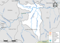 66160-Reynès-Routes-Hydro.png 3,507 × 2,480; 1.1 MB
-
 66160-Reynès-Sols.png 3,270 × 2,598; 2.85 MB
-
 66160-Reynès-ZNIEFF1.png 3,057 × 2,480; 7.8 MB
-
 66160-Reynès-ZNIEFF2.png 3,519 × 2,480; 7.97 MB
-
 66160-Reynès-Zone inondable.png 4,677 × 3,307; 11.35 MB
-
 Can Borrell 1812.png 462 × 688; 547 KB
-
 Canadells 1812.png 455 × 381; 349 KB
-
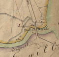 El Pont de Reiners 1812.png 481 × 468; 487 KB
-
 El Vilar de Reiners 1812.png 570 × 402; 493 KB
-
 La Cabanassa de Reiners 1812.png 561 × 558; 576 KB
-
 La Farga de Reiners 1812.png 391 × 330; 269 KB
-
 Localització de Reiners respecte del Vallespir.svg 483 × 244; 138 KB
-
 Map commune FR insee code 66160.png 756 × 605; 75 KB
-
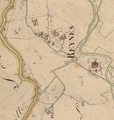 Reiners 1812.png 525 × 552; 506 KB
-
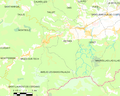
 Reiners en el seu entorn.png 749 × 557; 43 KB
-
 Vallera 1812.png 437 × 580; 489 KB


