Category:Maps of Raja Ampat Regency
Jump to navigation
Jump to search
Media in category "Maps of Raja Ampat Regency"
The following 33 files are in this category, out of 33 total.
-
 92.05.00 PapuaBarat Raja Ampat.svg 201 × 169; 862 KB
-
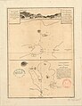 Admiralty Chart No 913 Harbours of Offak and Piapis on Waygiou, Published 1781.jpg 3,152 × 4,088; 2.58 MB
-
 Admiralty Chart No 914 Rawak Harbour on the north side of Waygiou, Published 1781.jpg 3,056 × 4,032; 2.6 MB
-

-
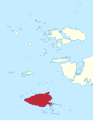
 Asia Islands (Raja Ampat) locator map.svg 514 × 701; 651 KB
-
 Batang Pele locator map.svg 543 × 701; 589 KB
-
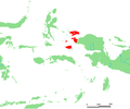
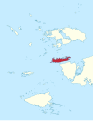 Batanta locator map.svg 543 × 701; 589 KB
-
 Forrest Chart of Kanary islands North of Mysol, Published 1781.jpg 3,120 × 4,000; 2.38 MB
-
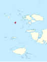 Gag locator map.svg 543 × 701; 589 KB
-
 ID Asia.PNG 670 × 561; 20 KB
-
 ID Boo.PNG 670 × 561; 20 KB
-
 ID Fam.PNG 670 × 561; 20 KB
-
 ID Gag.png 670 × 561; 20 KB
-
 ID Kofiau.PNG 670 × 561; 20 KB
-
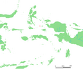
 ID Misool.PNG 670 × 561; 20 KB
-
 ID Raja Ampat.PNG 670 × 561; 20 KB
-
 ID Salawati.PNG 670 × 561; 20 KB
-
 ID Waigeo.PNG 670 × 561; 20 KB
-
 Jar (Raja Ampat) locator map.svg 543 × 701; 589 KB
-
 Kaart van de Papaosche Eilanden - btv1b8494429n.jpg 6,400 × 5,357; 3.95 MB
-
 Kabra Island map.svg 1,514 × 1,489; 3.08 MB
-
 Karta ID RajaAmpat Isl.PNG 450 × 600; 19 KB
-
 Kawe locator map.svg 543 × 701; 589 KB
-
 Kofiau locator map.svg 543 × 701; 589 KB
-
 Mansuar locator map.svg 543 × 701; 589 KB
-
 Misool locator map.svg 543 × 701; 589 KB
-
 Pulau Raja locator map.svg 543 × 701; 589 KB
-
 Raja Ampat locator map (blank).svg 543 × 701; 553 KB
-
 Raja Ampat locator map (blank, with Asia Islands).svg 514 × 701; 614 KB
-
 Sajang locator map.svg 514 × 701; 650 KB
-
 Salawati locator map.svg 543 × 701; 589 KB
-
 Warir Island map.svg 1,689 × 1,851; 4.65 MB
-
 Weeim locator map.svg 543 × 701; 589 KB


_locator_map.svg)


_locator_map.svg)


.svg)
.svg)