Category:Maps of Portoviejo
Jump to navigation
Jump to search
Subcategories
This category has only the following subcategory.
E
- Election maps of Portoviejo (2 F)
Media in category "Maps of Portoviejo"
The following 11 files are in this category, out of 11 total.
-
 Cantón Portoviejo.svg 1,870 × 1,280; 81 KB
-
 Foto aérea Portoviejo 1961.jpg 3,506 × 2,481; 5.71 MB
-
 Foto aérea Portoviejo 1977.jpg 3,506 × 2,481; 8.28 MB
-
 Foto aérea Portoviejo 1994.jpg 3,506 × 2,481; 5.96 MB
-
 Mapa cantón Portoviejo - GringoDJL - Parroquia Alhajuela.svg 1,870 × 1,280; 81 KB
-
 Mapa cantón Portoviejo - GringoDJL - Parroquia Calderón.svg 1,870 × 1,280; 81 KB
-
 Mapa cantón Portoviejo - GringoDJL - Parroquia Crucita.svg 1,870 × 1,280; 81 KB
-
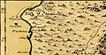
 Mapa de la Gobernación de Guayaquil 1.III.1804 - AHG.jpg 3,367 × 2,224; 2.24 MB
-
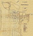 Mapa Portoviejo 13.07.1911, por Alonso Gonzalez Illescas.jpg 2,519 × 2,806; 4.9 MB
-
 Resultados Alcalde Portoviejo 2019 por parroquias.svg 1,870 × 1,280; 84 KB
-


_-_AHG.jpg)