<nowiki>Category:Maps of Padua; categoría de Wikimedia; kategori Wikimedia; Wikimedia category; د ويکيمېډيا وېشنيزه; Vikimedya kategorisi; ویکیمیڈیا زمرہ; kategória projektov Wikimedia; категорія проєкту Вікімедіа; 维基媒体分类; Wikimedia-Kategorie; Викимедиина категорија; kategorija na Wikimediji; विकिपीडिया:श्रेणी; page de catégorie de Wikimedia; kategorija na Wikimediji; विकिपीडिया वर्ग; категорија на Викимедији; Wikimedia-Kategorie; Wikimedia-kategori; kategori Wikimédia; تصنيف ويكيميديا; pajenn rummata eus Wikimedia; Wikimedia:ကဏ္ဍခွဲခြင်း; 維基媒體分類; Wikimedia категориясы; categoría de Wikimedia; categoria de Wikimedia; Викимедиа категорияһы; tudalen categori Wikimedia; Viciméid catagóir; Վիքիմեդիայի նախագծի կատեգորիա; 维基媒体分类; Wikimedia-kategory; ვიკიპედია:კატეგორიზაცია; ウィキメディアのカテゴリ; categoria Wikimedia; تصنيف بتاع ويكيميديا; විකිමීඩියා ප්රභේද පිටුව; categoria Vicimediorum; विकिमीडिया श्रेणी; Wikimedia-luokka; Wikimedia-categorie; விக்கிமீடியப் பகுப்பு; катэгорыя ў праекце Вікімэдыя; Викимедиа проектындагы төркем; catigurìa di nu pruggettu Wikimedia; หน้าหมวดหมู่วิกิมีเดีย; Wikimedia:Kategorija; Wikimedia-Kategorie; Wikimedia:Klassys; категория на Уикимедия; categorie a unui proiect Wikimedia; categurìa 'e nu pruggette Wikimedia; Wikimedia-kategori; kawan Wikimèdia; гурӯҳи Викимедиа; 위키미디어 분류; Wikimedia-bólkur; kategorio en Vikimedio; kategori Wikimedia; Wikimedia:Ronnaghys; উইকিমিডিয়া বিষয়শ্রেণী; kategori Wikimedia; 维基媒体分类; וויקימעדיע קאַטעגאָריע; kategorija w projektach Wikimedije; thể loại Wikimedia; Wikimedia projekta kategorija; kategoria ti Wikimedia; categoria de um projeto da Wikimedia; 维基媒体分类; категорияд Ангилал; Wikimedia-kategori; kategori Wikimedia; پۆلی ویکیمیدیا; Wikimedia category; Vikimédia ñemohenda; Wikimédia-kategória; વિકિપીડિયા શ્રેણી; Wikimediako kategoria; категория в проекте Викимедиа; Wikimedia-Kategorie; Kategoriya ning Wikimedia; Wikimedia-kategorie; Wîkîmediya:Kategorî; विकिमिडिया श्रेणी; Wikimedia-Kategorie; קטגוריה במיזמי ויקימדיה; Викимедиа проектындагы төркем; Wikimedia-categorie; विकिमिडिया श्रेणी; κατηγορία εγχειρημάτων Wikimedia; Wikimedia-kategoriija; гурӯҳи Викимедиа; kategoria w projekcie Wikimedia; categoría de Wikimedia; Wikimedia category; categoria di un progetto Wikimedia; 維基媒體分類; Wikimedia category; 維基媒體分類; Wikimedia kategooria; Wikimedia-categorie; Wikimedia-kategori; Wikimedia proyektındağı törkem; 維基媒體分類; ẹ̀ka Wikimedia; kategorie na projektech Wikimedia; categoria de um projeto da Wikimedia; Wikimedia-Kategorie; ردهٔ ویکیپدیا; tumbung Wikimedia; Wikimedia-kategorie; kategorija Wikimedie; kategorya ng Wikimedia; Wikimedia-Kategorie; Vikipidiya:Shopni; kategori Wikimedia; jamii ya Wikimedia; വിക്കിമീഡിയ വർഗ്ഗം; 維基媒體分類; kategori Wikimedia; Wikimedia-Kategorie; زمرو:وڪيپيڊيا زمرا بندي; kategori e Wikimedias; categoría de Wikimedia; guruhi Vikimedia; 维基媒体分类; катэгорыя ў праекце Вікімедыя</nowiki>
Subcategories
This category has the following 4 subcategories, out of 4 total.


.svg)

 Area metropolitana di Padova.gif 573 × 590; 49 KB
 Due-Carrare posizione.gif 600 × 371; 36 KB
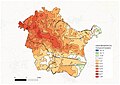 Fasce altimetriche Conselve.jpg 4,677 × 3,307; 982 KB
 Fiumi medio veneto.svg 1,050 × 600; 964 KB
 FlorimiMapPadua.png 1,531 × 1,058; 4.03 MB
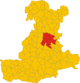 Map of comune of Padua (province of Padua, region Veneto, Italy).svg 3,144 × 3,265; 151 KB
 Mappa del Comune di Padova.jpg 1,600 × 1,542; 236 KB
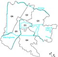 Mappa padova.jpg 564 × 549; 111 KB
 Padoue OSM 01.png 493 × 543; 244 KB
 Padoue OSM 02.png 493 × 543; 373 KB
 Padova antica.jpg 767 × 618; 286 KB
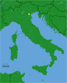 Padova dot.png 1,805 × 2,243; 178 KB
 Padova location map.png 681 × 669; 615 KB
 Patreve.jpg 2,000 × 2,141; 428 KB
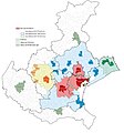 PatreveES.jpg 2,000 × 2,141; 428 KB
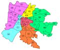 Quartieri Unità urbane padova.jpg 851 × 711; 76 KB


