Category:Maps of Ostrobothnia
Jump to navigation
Jump to search
Regions of Finland: Central Finland · Central Ostrobothnia · Finland Proper · Kainuu · Kymenlaakso · Lapland · North Karelia · Northern Ostrobothnia · Northern Savonia · Ostrobothnia · Pirkanmaa · Päijänne Tavastia · Satakunta · South Karelia · South Ostrobothnia · Southern Savonia · Tavastia Proper · Uusimaa · Åland
Subcategories
This category has the following 2 subcategories, out of 2 total.
O
V
Media in category "Maps of Ostrobothnia"
The following 6 files are in this category, out of 6 total.
-
 Finland Ostrobothnia Region.svg 1,000 × 1,247; 62 KB
-
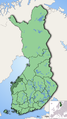 Finland regions Pohjanmaa.png 1,424 × 2,528; 805 KB
-
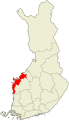
 Location of Pohjanmaa in Finland.png 230 × 400; 3 KB
-
 Pohjanmaa.png 2,000 × 3,500; 374 KB
-
 Pohjanmaa.sijainti.suomi.2010.svg 1,850 × 3,220; 64 KB
-
 Pohjanmaan.maakunta.suomi.2008.svg 1,850 × 3,220; 269 KB


