Category:Maps of Osterøy municipality
Jump to navigation
Jump to search
| NO WIKIDATA ID FOUND! Search for Maps of Osterøy municipality on Wikidata | |
| Upload media |
Media in category "Maps of Osterøy municipality"
The following 9 files are in this category, out of 9 total.
-
 HavreMap.jpg 555 × 327; 121 KB
-
 NO 1250 Haus.svg 746 × 747; 310 KB
-
 NO 1251 Bruvik.svg 746 × 747; 310 KB
-
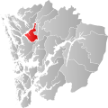
 NO 1253 Hosanger.svg 746 × 747; 310 KB
-
 NO 1253 Osterøy.svg 746 × 747; 258 KB
-
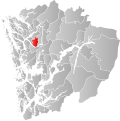
 NO 1254 Hamre.svg 746 × 747; 310 KB
-
 NO 4630 Osterøy.svg 920 × 1,346; 512 KB
-
 Norway Hordaland - Osterøy.svg 939 × 912; 289 KB
-
 TettstedetBergen.jpg 1,105 × 1,187; 817 KB


