Category:Maps of Opoul-Périllos
Jump to navigation
Jump to search
Wikimedia category | |||||
| Upload media | |||||
| Instance of | |||||
|---|---|---|---|---|---|
| Category combines topics | |||||
| Opoul-Périllos | |||||
commune in Pyrénées-Orientales, France  .svg)  | |||||
| Pronunciation audio | |||||
| Instance of | |||||
| Location | |||||
| Population |
| ||||
| Area |
| ||||
| Elevation above sea level |
| ||||
| official website | |||||
 | |||||
Media in category "Maps of Opoul-Périllos"
The following 12 files are in this category, out of 12 total.
-
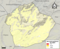 66127-Opoul-Périllos-argile.png 4,076 × 3,307; 5.94 MB
-
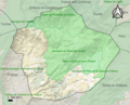
 66127-Opoul-Périllos-Natura2000.png 5,846 × 4,133; 11.46 MB
-
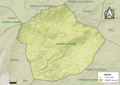
 66127-Opoul-Périllos-ZNIEFF1.png 3,057 × 2,480; 6.1 MB
-
 66127-Opoul-Périllos-ZNIEFF2.png 3,519 × 2,480; 6.59 MB
-
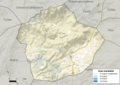 66127-Opoul-Périllos-Zone inondable.png 4,677 × 3,307; 7.86 MB
-
 Localització d'Òpol i Perellós respecte del Rosselló.svg 487 × 522; 365 KB
-
 Map commune FR insee code 66127.png 756 × 605; 60 KB
-
 Opoul carte topographique.jpg 1,441 × 1,336; 641 KB
-
 Opoul et Pyrénées.jpg 1,587 × 1,093; 358 KB
-
 Perellós el 1812.png 369 × 409; 303 KB
-
 Òpol 1 el 1812.png 540 × 428; 469 KB
-
 Òpol 3 el 1812.png 361 × 380; 246 KB


