Category:Maps of Massachusetts in art
Jump to navigation
Jump to search
States of the United States: Alabama · Alaska · Arizona · Arkansas · California · Colorado · Connecticut · Delaware · Florida · Georgia · Hawaii · Idaho · Illinois · Indiana · Iowa · Kansas · Kentucky · Louisiana · Maine · Maryland · Massachusetts · Michigan · Minnesota · Mississippi · Missouri · Montana · Nebraska · Nevada · New Hampshire · New Jersey · New Mexico · New York · North Carolina · North Dakota · Ohio · Oklahoma · Oregon · Pennsylvania · Rhode Island · South Carolina · South Dakota · Tennessee · Texas · Utah · Vermont · Virginia · Washington · West Virginia · Wisconsin · Wyoming – Washington, D.C.
Subcategories
This category has the following 3 subcategories, out of 3 total.
Media in category "Maps of Massachusetts in art"
The following 11 files are in this category, out of 11 total.
-
 Arbuckle Bros. Coffee Company (3093818876).jpg 799 × 479; 307 KB
-
 Elkanah Tisdale, The Gerry-Mander Map, 1813 Cornell CUL PJM 1034 01.jpg 3,000 × 4,929; 4.05 MB
-
 Forefathers Monument, Plymouth. Pilgrim Monument, Provincetown (68989).jpg 3,327 × 2,172; 2.34 MB
-
 MA gold medal.svg 77 × 105; 130 KB
-
 Massachusetts (4586563691).jpg 2,000 × 1,209; 3.27 MB
-
 MassFridgeMagnet.jpg 299 × 330; 55 KB
-
 MassLottoLogo.svg 198 × 64; 29 KB
-
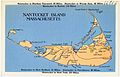 Nantucket Island, Massachusetts (66816).jpg 3,348 × 2,148; 1.95 MB
-
 Prospect Hill Monument plaque - Somerville, MA - DSC03347.JPG 4,320 × 3,240; 4.86 MB
-
 Untitled - Maps (NBY 2564).jpg 818 × 512; 143 KB
-
 William Dawes plaque, Cambridge, MA - IMG 4611.JPG 3,264 × 2,448; 4.39 MB
.jpg)

.jpg)

.jpg)

.jpg)

.jpg)
