Category:Maps of Massachusetts from the Norman B. Leventhal Map Center
Jump to navigation
Jump to search
Subcategories
This category has the following 3 subcategories, out of 3 total.
Media in category "Maps of Massachusetts from the Norman B. Leventhal Map Center"
The following 73 files are in this category, out of 73 total.
-
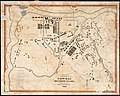
 1831 MtAuburnCemetery BPL3370528616.jpg 1,549 × 2,000; 2.84 MB
-
-
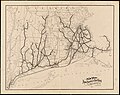
 1838 Southern New England railroad map.jpg 7,204 × 6,096; 39.17 MB
-
 1853 map of North Bridgewater, Massachusetts.jpg 8,824 × 6,584; 7.32 MB
-
 1858 Map of the county of Norfolk, Massachusetts.jpg 14,442 × 13,742; 28 MB
-
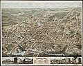
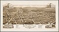
 1876 bird's eye view map of Haverhill, Massachusetts.jpg 9,224 × 5,856; 7.77 MB
-
 1876 bird's eye view map of Pittsfield, Massachusetts.jpg 9,632 × 7,784; 12.26 MB
-
 1876 bird's eye view of Lowell, Massachusetts; colored.jpg 9,768 × 7,272; 19.3 MB
-
 1878 bird's eye view map of Brockton, Massachusetts.jpg 8,601 × 6,903; 11.14 MB
-
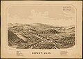 1879 bird's eye view map of Becket, Massachusetts.jpg 7,952 × 5,688; 4.94 MB
-
 1880 bird's eye view map of Campello, Brockton, Massachusetts.jpg 8,704 × 4,728; 5.72 MB
-
 1880 bird's eye view map of Newton Lower Falls, Massachusetts.jpg 8,128 × 7,024; 8.51 MB
-
 1881 bird's eye view map of Middleborough, Massachusetts.jpg 7,214 × 6,514; 7.78 MB
-
 1887 bird's eye view map of Highlandville, Massachusetts (2673654759).jpg 8,031 × 6,640; 9.25 MB
-
 1887 bird's eye view map of Needham, Massachusetts.jpg 7,696 × 6,560; 8.26 MB
-
 1887 Massachusetts railroads map.jpg 9,760 × 7,992; 24.82 MB
-
 1889 bird's eye view map of Middleborough, Massachusetts.jpg 10,496 × 7,368; 12 MB
-
 1891 preliminary plan for widening Chestnut Hill Avenue.jpg 10,256 × 3,592; 3.17 MB
-
 1893 bird's eye view map of Concord Junction, Massachusetts.jpg 10,176 × 8,000; 6.95 MB
-
 1893 bird's eye view map of Haverhill, Massachusetts.jpg 10,288 × 7,448; 11.86 MB
-
 1893 map of parks of the metropolitan district of Boston.jpg 8,712 × 7,984; 9.06 MB
-
 1894 New York, New Haven and Hartford Railroad map.jpg 5,761 × 4,560; 3.01 MB
-
 1899 bird's eye view map of Pittsfield, Massachusetts.jpg 7,928 × 5,608; 7.56 MB
-
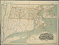 1899 Massachusetts railroads map.jpg 9,384 × 7,128; 19.48 MB
-

-
 1909 map of Brockton, Massachusetts.jpg 6,944 × 4,860; 4.21 MB
-
 1919 map Worcester Massachusetts BPL.jpg 829 × 1,024; 293 KB
-
 Aero view of Canton, Massachusetts, 1918.jpg 10,000 × 6,784; 14.37 MB
-
 Aero view of Lynn, Mass, 1916 - looking north (14966322891).jpg 2,000 × 1,300; 2.16 MB
-
 Bird's eye view map of Ayer, Massachusetts.jpg 8,397 × 5,708; 14.09 MB
-
 Belvidere Park, Lowell, Mass. (4586561917).jpg 9,280 × 5,760; 8.13 MB
-
 Bird's eye view map of Brockton, Massachusetts, circa 1882.jpg 9,760 × 6,544; 8.66 MB
-
 Boston Bay Nautical Chart 1776.jpg 10,751 × 7,677; 12.34 MB
-
 Canton Junction station on 1918 bird's eye view map.jpg 855 × 557; 149 KB
-
 Cape Cod Bay Nautical Chart 1879.jpg 13,098 × 10,617; 26.31 MB
-
 Cape Cod Bay, Massachusetts (8249864115).jpg 2,000 × 1,500; 2.08 MB
-
 City of Fall River, Mass - 1877 G3764.T2A3 1875B3.jpg 10,528 × 6,592; 46.95 MB
-
 City of Lowell (9137935278).jpg 799 × 562; 108 KB
-
 City of Taunton, Mass - G3764.T2A3 1875B3.jpg 10,320 × 7,464; 60.39 MB
-

-

-

-
-
 Haverhill Bridge and station on 1893 bird's eye view map.jpg 1,630 × 1,211; 459 KB
-
 Haverhill station on 1876 bird's eye view map.jpg 623 × 461; 69 KB
-
 Haverhill station on 1893 bird's eye view map.jpg 1,241 × 838; 285 KB
-

-
 Hyde Park (B&P) station on 1879 bird's eye view map.jpg 489 × 331; 39 KB
-
 Hyde Park (NY&NE) station on 1879 bird's eye view map.jpg 350 × 272; 25 KB
-
 Hyde Park (NY&NE) station on 1890 bird's eye view map.jpg 577 × 445; 67 KB
-
 Hyde Park station on 1890 bird's eye view map.jpg 787 × 565; 117 KB
-
 Hyde Park, Massachusetts (2674953663).jpg 9,136 × 6,816; 46.4 MB
-
 Map of Boston and the country adjacent, from actual surveys (14782735589).jpg 1,953 × 2,000; 4.32 MB
-
 Map of Pepperell, Mass. - 1844 (14775617887).jpg 2,000 × 1,664; 2.24 MB
-

-
 Middleborough freight house on 1889 bird's eye view map.jpg 775 × 530; 113 KB
-
 Middleborough station on 1889 bird's eye view map.jpg 1,204 × 713; 242 KB
-
 Middleborough Yard on 1881 bird's eye view map.jpg 1,868 × 1,178; 555 KB
-
 Needham station on 1887 bird's eye view map.jpg 869 × 471; 105 KB
-
 Newton Lower Falls Branch terminal from 1880 bird's eye view map.jpg 2,322 × 1,366; 719 KB
-

-
 Plan of land in Ayers New-City, Lowell, Mass. (4587187052).jpg 1,345 × 2,000; 2.07 MB
-
 Plan of the city of Lowell, Massachusetts (2675392914).jpg 2,000 × 1,728; 3.44 MB
-
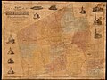
 Plan of the county of Essex (14967091671).jpg 2,000 × 1,794; 2.56 MB
-
 Readville stations on 1879 bird's eye view map.jpg 674 × 454; 80 KB
-
 Taunton station and roundhouse on 1875 bird's eye view map.jpg 1,168 × 780; 237 KB
-
 Thirty-miles round Boston (2674599239).jpg 2,000 × 1,955; 3.32 MB
-

-
 View of Grafton, Massachusetts (2674470068).jpg 10,312 × 7,152; 19.71 MB
-
 View of Hyde Park, Mass., 1879 G3764.B6-2H9A3 1879B35.jpg 7,832 × 5,896; 7.48 MB
-
 View of the city of New Bedford, Mass - 1876 G3764.N4A3 1876O43.jpg 10,520 × 6,992; 11.45 MB
-

-


.jpg)


.jpg)

.jpg)


.jpg)

.jpg)


.jpg)


_station_on_1879_bird%27s_eye_view_map.jpg)
_station_on_1879_bird%27s_eye_view_map.jpg)
_station_on_1890_bird%27s_eye_view_map.jpg)

.jpg)
.jpg)
.jpg)


.jpg)
.jpg)
.jpg)


.jpg)
.jpg)
.jpg)


