Category:Maps of Mérobert
Jump to navigation
Jump to search
Wikimedia category | |||||
| Upload media | |||||
| Instance of | |||||
|---|---|---|---|---|---|
| Category combines topics | |||||
| Mérobert | |||||
commune in Essonne, France  .svg)  | |||||
| Instance of | |||||
| Location |
| ||||
| Head of government |
| ||||
| Population |
| ||||
| Area |
| ||||
| official website | |||||
 | |||||
Media in category "Maps of Mérobert"
The following 12 files are in this category, out of 12 total.
-
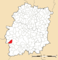 91 Communes Essonne Merobert.png 723 × 750; 166 KB
-
 91393-Mérobert - Localisation.png 2,500 × 2,480; 1,017 KB
-
 91393-Mérobert-cadastre.png 7,015 × 4,960; 4.24 MB
-
 91393-Mérobert-géologie.png 7,015 × 4,960; 2.73 MB
-
 91393-Mérobert-Hydro.jpeg 5,846 × 4,133; 1.16 MB
-
 91393-Mérobert-Hydro.png 7,015 × 4,960; 2.32 MB
-
 91393-Mérobert-Natura 2000.png 7,015 × 4,960; 2.02 MB
-
 91393-Mérobert-Orthophoto.png 7,015 × 4,960; 4.52 MB
-
 91393-Mérobert-sols.png 7,015 × 4,960; 2.63 MB
-
 91393-Mérobert-ZNIEFF1.png 7,015 × 4,960; 2.06 MB
-
 91393-Mérobert-ZNIEFF2.png 7,015 × 4,960; 2.18 MB
-
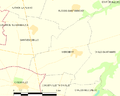 Map commune FR insee code 91393.png 756 × 605; 25 KB


