Category:Maps of Liège in the 18th century
Jump to navigation
Jump to search
Media in category "Maps of Liège in the 18th century"
The following 15 files are in this category, out of 15 total.
-
 1725-Liege-Bodenher.jpg 3,500 × 2,000; 2.66 MB
-
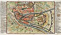
 Plan de Liège 1746.jpg 9,454 × 7,068; 6.86 MB
-

-
 1757 Leige detail of map Seat of War in the Circle of Westphalia BPL 14521.png 1,011 × 747; 1.41 MB
-
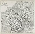
 Plan de Liège 17xx.jpg 6,705 × 6,584; 5.4 MB
-
 2014 Liège, Archéoforum (03).jpg 1,728 × 1,152; 1.13 MB
-
 2014 Liège, Archéoforum (04).jpg 1,728 × 1,152; 1.04 MB
-
 2014 Liège, Archéoforum (05).jpg 1,667 × 1,152; 1.07 MB
-
 Enclaves near Liège and Maastricht.jpg 960 × 1,280; 469 KB
-
 Georges-Louis Le Rouge - Plan de Liège.jpg 2,858 × 2,768; 3.23 MB
-
 Map liege 3.jpg 4,222 × 3,330; 5.14 MB
-
 Map of Liège by Jacobus Harrewijn in 1785.jpg 6,028 × 4,708; 2.89 MB
-
 PbLuik1786.png 325 × 411; 283 KB
-
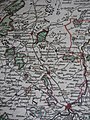
 Principauté de Liège et Comté de Namur - 1747.jpg 520 × 694; 84 KB
-
 The BL King’s Topographical Collection- "PLAN DE LA CITADELLE DE LIEGE.".jpg 4,000 × 2,931; 2.64 MB


_-_Geographicus_-_Leodiensis-lafeuille-1747.jpg)


.jpg)
.jpg)
.jpg)


