Category:Maps of Le Fel (Aveyron)
Jump to navigation
Jump to search
Media in category "Maps of Le Fel (Aveyron)"
The following 11 files are in this category, out of 11 total.
-
 12093-Le Fel-Arron.png 3,057 × 2,480; 1.25 MB
-
 12093-Le Fel-cadastre.svg 961 × 744; 4.02 MB
-
 12093-Le Fel-Canton.png 3,057 × 2,480; 1.26 MB
-
 12093-Le Fel-EPCI.png 3,057 × 2,480; 1.26 MB
-
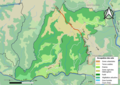
 12093-Le Fel-Natura2000.png 7,039 × 4,960; 3.64 MB
-
 12093-Le Fel-Sols.png 3,507 × 2,480; 2.01 MB
-
 12093-Le Fel-ZNIEFF1.png 3,519 × 2,480; 1.78 MB
-
 12093-Le Fel-ZNIEFF2.png 3,519 × 2,480; 1.61 MB
-
 12093-Le Fel-Zone inondable.svg 1,070 × 744; 3.01 MB
-
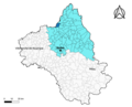
 Map commune FR insee code 12093.png 756 × 605; 48 KB
-
 Périmètre RNR Coteaux du Fel rnr227.png 800 × 740; 297 KB


