Category:Maps of Lappeenranta
Jump to navigation
Jump to search
Wikimedia category | |||||
| Upload media | |||||
| Instance of | |||||
|---|---|---|---|---|---|
| Category combines topics | |||||
| Lappeenranta | |||||
city in the region of South Karelia in Finland    | |||||
| Instance of | |||||
| Location |
| ||||
| Located in or next to body of water | |||||
| Legislative body |
| ||||
| Official language | |||||
| Head of government |
| ||||
| Inception |
| ||||
| Significant event |
| ||||
| Population |
| ||||
| Area |
| ||||
| Replaces | |||||
| Different from | |||||
| official website | |||||
 | |||||
Subcategories
This category has the following 6 subcategories, out of 6 total.
- Maps of Lauritsala (3 F)
- Maps of Nuijamaa (5 F)
- Maps of Ylämaa (4 F)
O
Media in category "Maps of Lappeenranta"
The following 16 files are in this category, out of 16 total.
-
 Harapainen.jpg 569 × 340; 89 KB
-
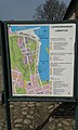
 Jouko reittiopas.jpg 1,440 × 2,600; 521 KB
-
 Jouko route guide.jpg 1,437 × 2,714; 492 KB
-
 Jukola relay 2016 - 01.jpg 4,256 × 2,832; 6.42 MB
-
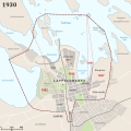 Lappeenranta 1930.svg 1,000 × 1,000; 550 KB
-
 Lappeenranta ja Lauritsala 1965.svg 2,000 × 2,000; 1.47 MB
-
 Lappeenranta kuntaliitokset.svg 2,000 × 2,500; 1.82 MB
-
 Lappeenranta sijainti Suomi.svg 1,750 × 2,950; 715 KB
-
 Lappeenranta.sijainti.suomi.2007.svg 1,850 × 3,220; 269 KB
-
 Lappeenranta.sijainti.suomi.2008.svg 1,850 × 3,220; 269 KB
-
 Lappeenranta.sijainti.suomi.2009.svg 1,850 × 3,220; 233 KB
-
 Lappeenranta.sijainti.suomi.2010.svg 1,850 × 3,220; 235 KB
-
 Lappeenranta.sijainti.Suomi.2020.svg 1,750 × 2,950; 885 KB
-
 Linnoituksen kartta 19.4.2014.jpg 1,536 × 2,560; 1.53 MB
-
 Linnoituksen kartta II, 19.04.2014.jpg 1,536 × 2,560; 1.64 MB
-
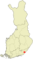
 Location of Lappeenranta in Finland.png 230 × 400; 6 KB


