Category:Maps of Landkreis Mansfeld-Südharz
Jump to navigation
Jump to search
Districts of Saxony-Anhalt:
Urban districts (cities):
| NO WIKIDATA ID FOUND! Search for Maps of Landkreis Mansfeld-Südharz on Wikidata | |
| Upload media |
Subcategories
This category has the following 3 subcategories, out of 3 total.
Media in category "Maps of Landkreis Mansfeld-Südharz"
The following 13 files are in this category, out of 13 total.
-
 Einzugs- und Flussgebietskarte Helme.png 1,134 × 763; 1,016 KB
-
 Einzugs- und Flussgebietskarte Wipper (Saale).png 732 × 668; 620 KB
-
 Einzugsgebiet der Helme und Kleiner Helme.jpg 1,031 × 760; 138 KB
-
 Flugplatzbahn Allstedt OSM 2023-06-27.png 3,207 × 1,431; 1.64 MB
-
 Helme - Einzugsgebiet- Derzeitige Aufteilung auf Bundesländer.jpg 1,031 × 760; 97 KB
-
 Helmeeinzugsgebiet- Derzeitige aufteilung auf die Bundesländer .jpg 1,211 × 633; 87 KB
-
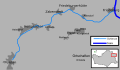 KarteSchlenze.svg 858 × 494; 130 KB
-
 Lage des Landkreises Mansfeld-Südharz in Deutschland.png 197 × 235; 3 KB
-
 Locator map MSH in Germany.svg 1,075 × 1,273; 570 KB
-
 Locator map MSH in Saxony-Anhalt.svg 1,957 × 2,306; 786 KB
-
 Mansfeld-Südharz in S-A.svg 500 × 657; 31 KB
-
 Municipalities in MSH.svg 1,293 × 914; 699 KB
-
 Saxony anhalt msh.png 364 × 467; 5 KB

.png)


