Category:Maps of Kuşadası
Jump to navigation
Jump to search
Media in category "Maps of Kuşadası"
The following 6 files are in this category, out of 6 total.
-
 Admiralty Chart No 1546 Samos Strait to Mandelyah Gulf, Published 1898.jpg 8,390 × 12,359; 14 MB
-
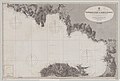
 Admiralty Chart No 1893 Sighajik Bay To The Gulf Of Scala Nuova, Published 1836.jpg 7,651 × 5,866; 11.77 MB
-
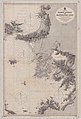
 Admiralty Chart No 3446 Paspargo Islet to Samos Strait (Turkey and Greece), Published 1905.jpg 12,433 × 8,396; 13.68 MB
-
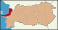 Aydın location Kuşadası.svg 835 × 429; 184 KB
-
 Chart of the Bay of Sighajik - by Francis Beaufort F.R.S - 1811 and 1812 RMG L6252.tiff 4,800 × 3,801; 52.2 MB
-
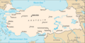 Location kusadasi.gif 634 × 323; 21 KB


,_Published_1905.jpg)

