<nowiki>Category:Maps of Kollam; categoría de Wikimedia; kategori Wikimedia; Wikimedia category; د ويکيمېډيا وېشنيزه; Vikimedya kategorisi; ویکیمیڈیا زمرہ; kategória projektov Wikimedia; категорія проєкту Вікімедіа; 维基媒体分类; Wikimedia-Kategorie; Викимедиина категорија; Wikimedia-Kategorie; विकिपीडिया:श्रेणी; page de catégorie de Wikimedia; kategorija na Wikimediji; विकिपीडिया वर्ग; категорија на Викимедији; Wikimedia-Kategorie; Wikimedia-kategori; kategori Wikimédia; تصنيف ويكيميديا; pajenn rummata eus Wikimedia; Wikimedia:ကဏ္ဍခွဲခြင်း; 維基媒體分類; Wikimedia категориясы; categoría de Wikimedia; Wikimedia-categorie; Wikimedia-Kategorie; tudalen categori Wikimedia; Viciméid catagóir; ردهٔ ویکیپدیا; 维基媒体分类; Wikimedia-kategory; ვიკიპედია:კატეგორიზაცია; ウィキメディアのカテゴリ; categoria Wikimedia; تصنيف بتاع ويكيميديا; විකිමීඩියා ප්රභේද පිටුව; categoria Vicimediorum; Vikipidiya:Shopni; Wikimedia-luokka; Wikimedia-categorie; guruhi Vikimedia; катэгорыя ў праекце Вікімэдыя; Викимедиа проектындагы төркем; catigurìa di nu pruggettu Wikimedia; หน้าหมวดหมู่วิกิมีเดีย; Wikimedia:Kategorija; Wikimedia-Kategorie; Wikimedia:Klassys; категория на Уикимедия; categorie a unui proiect Wikimedia; categurìa 'e nu pruggette Wikimedia; Wikimedia-kategori; kawan Wikimèdia; гурӯҳи Викимедиа; 위키미디어 분류; Wikimedia-bólkur; kategorio en Vikimedio; kategori Wikimedia; categoría de Wikimedia; উইকিমিডিয়া বিষয়শ্রেণী; kategori Wikimedia; 维基媒体分类; וויקימעדיע קאַטעגאָריע; kategorija w projektach Wikimedije; thể loại Wikimedia; Wikimedia projekta kategorija; kategoria ti Wikimedia; categoria de um projeto da Wikimedia; Wikimedia category; категорияд Ангилал; Wikimedia-kategori; kategori Wikimedia; پۆلی ویکیمیدیا; Wikimedia category; Vikimédia ñemohenda; Wikimédia-kategória; વિકિપીડિયા શ્રેણી; Wikimediako kategoria; категория в проекте Викимедиа; Wikimedia-Kategorie; катэгорыя ў праекце Вікімедыя; Wikimedia-kategorie; Wîkîmediya:Kategorî; विकिमिडिया श्रेणी; Wikimedia-Kategorie; קטגוריה במיזמי ויקימדיה; Викимедиа проектындагы төркем; 維基媒體分類; विकिमिडिया श्रेणी; 维基媒体分类; Wikimedia-kategoriija; гурӯҳи Викимедиа; Wikimedia-categorie; kategoria w projekcie Wikimedia; Wikimedia:Ronnaghys; categoria di un progetto Wikimedia; Wikimedia category; 维基媒体分类; விக்கிமீடியப் பகுப்பு; Wikimedia kategooria; 維基媒體分類; Wikimedia-kategori; Վիքիմեդիայի նախագծի կատեգորիա; kategorya ng Wikimedia; ẹ̀ka Wikimedia; 維基媒體分類; categoria de um projeto da Wikimedia; kategorie na projektech Wikimedia; kategorija na Wikimediji; tumbung Wikimedia; Викимедиа категорияһы; kategorija Wikimedie; Wikimedia proyektındağı törkem; Wikimedia-kategorie; Wikimedia-Kategorie; kategori Wikimedia; jamii ya Wikimedia; വിക്കിമീഡിയ വർഗ്ഗം; 維基媒體分類; kategori Wikimedia; Kategoriya ning Wikimedia; زمرو:وڪيپيڊيا زمرا بندي; categoria de Wikimedia; categoría de Wikimedia; kategori e Wikimedias; κατηγορία εγχειρημάτων Wikimedia; विकिमीडिया श्रेणी</nowiki>
Subcategories
This category has only the following subcategory.


 13-kollam.png 748 × 903; 88 KB
 13-kollam.svg 744 × 1,052; 43 KB
 Admiralty Chart No 750 Malabar Coast of India from 9°53' to 8°40' north latitude, Published 1857.jpg 8,362 × 12,460; 10.62 MB
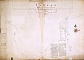 AMH-2605-NA Representation of Fort Coylan's reduction in size.jpg 2,400 × 1,720; 522 KB
 Battle between Dutch and Portuguese at Quilon, 1661.jpg 895 × 1,192; 328 KB
 Fight between Dutch and Portuguese at Quilon, in 1661.jpg 947 × 1,200; 376 KB
 Kollam by António Bocarro in 1635.jpg 379 × 211; 81 KB
 Kollam City Map.png 610 × 474; 386 KB
 Kollam.svg 1,244 × 906; 210 KB
 Location of Kollam Kerala.png 251 × 420; 9 KB
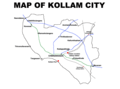 Map of Kollam City, Jul 2020.png 1,216 × 900; 76 KB
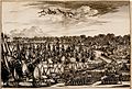 Quilon 1670 verbessert.jpg 2,044 × 1,388; 1.44 MB
 Thangassery 17th Century Dutch map.jpg 1,192 × 785; 375 KB
 Van Goens in Coylang.jpg 915 × 1,200; 323 KB
 View of Coylang Bay Decker, Coenraet.jpg 1,568 × 1,062; 456 KB
 View of the fort at Coilan Rick, John.jpg 1,476 × 1,045; 195 KB


,_by_Gaspar_Correia.jpg)


