Category:Maps of Kalinga (province)
Jump to navigation
Jump to search
- Provinces of the Philippines Abra · Agusan del Norte · Agusan del Sur · Aklan · Albay · Antique · Apayao · Aurora · Basilan · Bataan · Batanes · Batangas · Benguet · Biliran · Bohol · Bukidnon · Bulacan · Cagayan · Camarines Norte · Camarines Sur · Camiguin · Capiz · Catanduanes · Cavite · Cebu · Cotabato · Davao de Oro · Davao del Norte · Davao del Sur · Davao Occidental · Davao Oriental · Dinagat Islands · Eastern Samar · Guimaras · Ifugao · Ilocos Norte · Ilocos Sur · Iloilo · Isabela · Kalinga · La Union · Laguna · Lanao del Norte · Lanao del Sur · Leyte · Maguindanao del Norte · Marinduque · Masbate · Misamis Occidental · Misamis Oriental · Mountain Province · Negros Occidental · Negros Oriental · Northern Samar · Nueva Ecija · Nueva Vizcaya · Occidental Mindoro · Oriental Mindoro · Palawan · Pampanga · Pangasinan · Quezon · Quirino · Rizal · Romblon · Samar · Sarangani · Siquijor · Sorsogon · South Cotabato · Southern Leyte · Sultan Kudarat · Sulu · Surigao del Norte · Surigao del Sur · Tarlac · Tawi-Tawi · Zambales · Zamboanga del Norte · Zamboanga del Sur · Zamboanga Sibugay ·
- Province-level divisions (independent cities, Metro Manila) Davao City · Metro Manila · Puerto Princesa · Zamboanga City ·
Pages in category "Maps of Kalinga (province)"
This category contains only the following page.
Media in category "Maps of Kalinga (province)"
The following 22 files are in this category, out of 22 total.
-
 CAR Map - Kalinga location.png 500 × 935; 54 KB
-
 Kalinga in Philippines.svg 1,869 × 2,465; 924 KB
-
 Kalinga Labelled Map.png 720 × 514; 89 KB
-
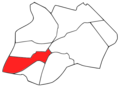
 Kalinga Map locator-Balbalan.png 576 × 420; 45 KB
-
 Kalinga Map locator-Lubuagan.png 576 × 420; 44 KB
-
 Kalinga Map locator-Pasil.png 576 × 420; 44 KB
-
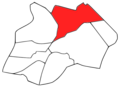 Kalinga Map locator-Pinukpuk.png 576 × 420; 45 KB
-
 Kalinga Map locator-Rizal.png 576 × 420; 44 KB
-
 Kalinga Map locator-Tabuk.png 576 × 420; 45 KB
-
 Kalinga Map locator-Tanudan.png 576 × 420; 45 KB
-
 Kalinga Map locator-Tinglayan.png 576 × 420; 44 KB
-
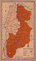 Mountain province 1918 map.jpg 615 × 1,022; 244 KB
-
 Ph fil kalinga.png 938 × 625; 124 KB
-
 Ph locator kalinga balbalan.png 300 × 250; 10 KB
-
 Ph locator kalinga lubuagan.png 300 × 250; 10 KB
-
 Ph locator kalinga pasil.png 300 × 250; 10 KB
-
 Ph locator kalinga pinukpuk.png 300 × 250; 10 KB
-
 Ph locator kalinga rizal.png 300 × 250; 10 KB
-
 Ph locator kalinga tabuk.png 300 × 250; 10 KB
-
 Ph locator kalinga tanudan.png 300 × 250; 10 KB
-
 Ph locator kalinga tinglayan.png 300 × 250; 10 KB
-
 Ph locator map kalinga.png 300 × 440; 19 KB


