Category:Maps of Jujuy Province
Jump to navigation
Jump to search
- Provinces of Argentina
- Buenos Aires
- Catamarca
- Chaco
- Chubut
- Córdoba
- Corrientes
- Entre Ríos
- Formosa
- Jujuy
- La Pampa
- La Rioja
- Mendoza
- Misiones
- Neuquén
- Río Negro
- Salta
- San Juan
- San Luis
- Santa Cruz
- Santa Fe
- Santiago del Estero
- Tierra del Fuego
- Tucumán
- Autonomous city
- Buenos Aires
Subcategories
This category has the following 4 subcategories, out of 4 total.
E
L
S
Media in category "Maps of Jujuy Province"
The following 16 files are in this category, out of 16 total.
-
 Provincia de Jujuy, Argentina.png 520 × 1,004; 13 KB
-
 Provincia de Jujuy (Argentina).png 568 × 937; 19 KB
-
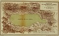 Boletin de la Academia Nacional de Ciencias en Córdoba (20379690912).jpg 3,742 × 2,302; 3.06 MB
-
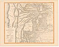 Carte des provinces de Salta et de Jujuy et d'une partie de la Bolivie.jpg 3,594 × 2,835; 1.93 MB
-
 Gran San Salvador de Jujuy.svg 644 × 495; 926 KB
-
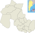
 Jujuy (Argentina).png 481 × 481; 10 KB
-
 Jujuy Köppen.svg 512 × 646; 129 KB
-
 Jujuy numérotée.PNG 640 × 600; 92 KB
-
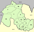
 Jujuy province (Argentina), departments and capital.png 669 × 627; 37 KB
-
 Map of Jujuy Province.svg 2,707 × 2,500; 888 KB
-

-
-

-

-
 Sitios arqueológicos de la cuenca del rio Barrancas.png 1,158 × 1,778; 1.81 MB
-
 Tipos de clima de Jujuy (Köppen).svg 512 × 646; 132 KB

.png)
.jpg)


.png)


,_departments_and_capital.png)

_-_Provincia_de_Jujuy_-_Fisico_(2016).jpg)
_-_Provincia_de_Jujuy_-_Pol%C3%ADtico_(2016).jpg)
_-_Provincia_de_Jujuy_-_Satelital_(2016).jpg)

.svg)