Category:Maps of Jonava District Municipality
Jump to navigation
Jump to search
Subcategories
This category has the following 3 subcategories, out of 3 total.
J
- Jonava in maps (5 F)
M
- Maps of Jonava (7 F)
Media in category "Maps of Jonava District Municipality"
The following 10 files are in this category, out of 10 total.
-
 Jonava bus station12.JPG 3,936 × 5,248; 4.65 MB
-
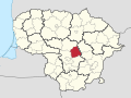
 Jonava district location.png 623 × 503; 20 KB
-
 Jonava district location.svg 1,095 × 821; 115 KB
-
 Jonava dst.svg 1,000 × 800; 717 KB
-
 Jonava Forestry 7.JPG 3,936 × 5,248; 6.09 MB
-
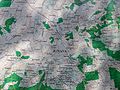 Jonava Forestry 8.JPG 5,248 × 3,936; 6.36 MB
-
 Jonava Forestry 9.JPG 5,248 × 3,936; 5.86 MB
-
 Jonava in Lithuania.svg 1,095 × 821; 524 KB
-
 Jonavos rajono savivaldybė.svg 718 × 718; 56 KB
-
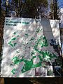
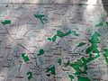
 JonavosRajonoSeniunijos.png 621 × 570; 290 KB


