Category:Maps of Islay
Jump to navigation
Jump to search
Wikimedia category | |||||
| Upload media | |||||
| Instance of | |||||
|---|---|---|---|---|---|
| Category combines topics | |||||
| Islay | |||||
southernmost island of the Inner Hebrides in Argyll and Bute, Scotland, UK   | |||||
| Instance of | |||||
| Part of | |||||
| Location |
| ||||
| Located in or next to body of water | |||||
| Capital | |||||
| Width |
| ||||
| Length |
| ||||
| Highest point |
| ||||
| Population |
| ||||
| Area |
| ||||
| Elevation above sea level |
| ||||
 | |||||
Media in category "Maps of Islay"
The following 35 files are in this category, out of 35 total.
-

-
 The Isle of Ila &c. Part of Argyle Shire - By H. Moll - btv1b530568483.jpg 3,520 × 2,816; 1.44 MB
-

-

-

-

-

-

-

-
 Admiralty Chart No 2515 Scotland west coast Mull of Cantyre to Ardnamurchan, Published 1868.jpg 10,249 × 12,652; 15.3 MB
-
 Admiralty Chart No 3116 Island of Islay, Published 1967.jpg 11,284 × 16,325; 27.21 MB
-
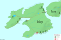 Distilleries Islay updated 2011.png 1,125 × 738; 80 KB
-
 Distilleries Islay.png 1,126 × 739; 35 KB
-
 Ila Insula by Blaeu 1665.jpg 9,090 × 6,705; 8.48 MB
-
 Islay Geology.png 747 × 917; 126 KB
-
 Islay in Southern Argyll.svg 885 × 655; 3.56 MB
-
 Islay Inner Hebrides.svg 1,161 × 2,563; 4.35 MB
-
 Islay map-de.svg 903 × 1,016; 1.32 MB
-
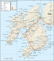 Islay map-en.svg 903 × 1,016; 1.32 MB
-
 Islay map-fr.svg 903 × 1,016; 1.32 MB
-
 Islay map-gd.svg 903 × 1,016; 1.27 MB
-
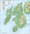
 Islay topographic map-de.svg 903 × 1,016; 1.48 MB
-
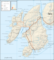
 Islay topographic map-en.svg 903 × 1,016; 1.48 MB
-
 Islay topographic map-fr.svg 903 × 1,016; 1.48 MB
-
 Islay.PNG 199 × 218; 4 KB
-
 Islay.svg 300 × 300; 99 KB
-
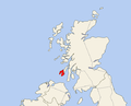 Location of Islay.png 542 × 439; 17 KB
-
 Lochindaalmap.jpg 412 × 508; 67 KB
-
 Map Islay.png 253 × 372; 34 KB
-
 Ordnance Survey One-Inch Sheet 57 Islay, Published 1955.jpg 8,621 × 10,692; 14.61 MB
-
 Ordnance Survey One-Inch Sheet 69 Islay, Published 1926.jpg 12,290 × 13,996; 25.16 MB
-
 Read Page022 Islay Colonsay Jura.jpg 1,356 × 1,389; 185 KB
-
 The Quarterly journal of the Geological Society of London (1916) (14784622702).jpg 2,164 × 2,505; 711 KB
-
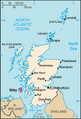
 UK Islay.PNG 648 × 584; 20 KB
-
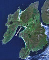
 Wfm islay landsat.jpg 1,280 × 948; 285 KB
.jpg)

%27_(11232570504).jpg)
%27_(11230562274).jpg)
%27_(11232184785).jpg)
%27_(11231025054).jpg)
%27_(11232929963).jpg)
%27_(11232536953).jpg)


_(14784622702).jpg)
