Category:Maps of Internet penetration
Jump to navigation
Jump to search
Subcategories
This category has only the following subcategory.
W
Media in category "Maps of Internet penetration"
The following 12 files are in this category, out of 12 total.
-
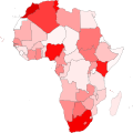 African internet 2015.svg 997 × 996; 324 KB
-
 BrowserUsage-January2020.svg 854 × 443; 1.59 MB
-
 California County Map Showing Broadband Access, 2011.svg 512 × 857; 674 KB
-
 California County Map Showing Broadband Access.png 358 × 599; 63 KB
-
 Centurylink DSL ISP Coverage Map.png 684 × 376; 83 KB
-
 CenturyLink network map.jpg 2,873 × 1,577; 824 KB
-
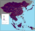
 EA Iusers 2008.png 995 × 905; 344 KB
-
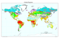
 Internet Access by Country (2017).svg 816 × 510; 3.32 MB
-
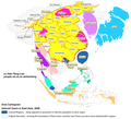
 Internet access in the Arab World (2011).svg 940 × 477; 540 KB
-
 P1994-2011.gif 590 × 525; 810 KB
-
 US Wireline Broadband 31Dec2012.tiff 761 × 384; 297 KB
-
 USDA Map Global2.png 10,200 × 6,600; 2.65 MB


.svg)
.svg)

