Category:Maps of Ialomița County
Jump to navigation
Jump to search
Counties of Romania: Alba · Arad · Argeș · Bacău · Bihor · Bistrița-Năsăud · Botoșani · Brașov · Brăila · Buzău · Caraș-Severin · Cluj · Constanța · Covasna · Călărași · Dolj · Dâmbovița · Galați · Giurgiu · Gorj · Harghita · Hunedoara · Ialomița · Iași · Ilfov · Maramureș · Mehedinți · Mureș · Neamț · Olt · Prahova · Sălaj · Satu Mare · Sibiu · Suceava · Teleorman · Timiș · Tulcea · Vâlcea · Vaslui · Vrancea – Capital city: Bucharest
Wikimedia category | |||||
| Upload media | |||||
| Instance of | |||||
|---|---|---|---|---|---|
| Category combines topics | |||||
| Ialomița County | |||||
county of Romania      | |||||
| Pronunciation audio | |||||
| Instance of |
| ||||
| Location | Romania | ||||
| Capital | |||||
| Legislative body |
| ||||
| Population |
| ||||
| Area |
| ||||
| official website | |||||
 | |||||
Subcategories
This category has the following 9 subcategories, out of 9 total.
A
- Maps of Amara, Romania (3 F)
C
- Maps of Căzănești (3 F)
E
F
- Maps of Fetești (3 F)
- Maps of Fierbinți-Târg (3 F)
S
- Maps of Slobozia (5 F)
T
- Maps of Țăndărei (3 F)
U
- Maps of Urziceni (3 F)
Media in category "Maps of Ialomița County"
The following 11 files are in this category, out of 11 total.
-
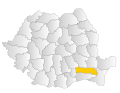
 Ialomita.png 283 × 214; 9 KB
-
 Ialomita.svg 1,300 × 1,000; 290 KB
-
 Ialomita County.svg 1,958 × 1,380; 1.05 MB
-
 Ialomita in Romania.svg 1,611 × 1,152; 815 KB
-
 Judetul Ialomita 3D map.jpg 1,062 × 764; 184 KB
-
 Provinz Ialomita Romania CIA2006.png 500 × 500; 589 KB
-
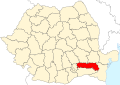
 Romania Ialomita Location map.jpg 918 × 414; 66 KB
-
 Map of the Ialomița County, all localities highlighted.svg 2,654 × 1,170; 390 KB
-
 Map of the Ialomița County, highlighted, no internal borders.svg 2,654 × 1,170; 148 KB
-
 Map of the Ialomița County, no highlight, no internal borders.svg 2,654 × 1,170; 148 KB
-
 Map of the Ialomița County, no highlight, with internal borders.svg 2,654 × 1,170; 390 KB


