Category:Maps of Guanacaste Province
Jump to navigation
Jump to search
Subcategories
This category has only the following subcategory.
M
Media in category "Maps of Guanacaste Province"
The following 11 files are in this category, out of 11 total.
-
 Costa Rica Guanacaste.png 207 × 190; 6 KB
-
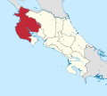 Guanacaste in Costa Rica.svg 1,148 × 1,034; 432 KB
-

-
-
 Costa Rica Guanacaste (1).png 207 × 190; 15 KB
-
 Admiralty Chart No 1931 Golfo de Nicoya, Published 1950.jpg 11,028 × 16,187; 58.41 MB
-

-
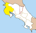
 Costa Rica Guanacaste location map.svg 464 × 566; 1.51 MB
-
 Costa Rica Partido de Nicoya.png 2,000 × 1,925; 45 KB
-
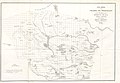
 MapaGuanacaste1924.png 1,785 × 2,385; 7.48 MB
-


.jpg)
.jpg)
.png)


