<nowiki>Category:Maps of Extertal; categoría de Wikimedia; kategori Wikimedia; Wikimedia category; د ويکيمېډيا وېشنيزه; Vikimedya kategorisi; ویکیمیڈیا زمرہ; kategória projektov Wikimedia; категорія проєкту Вікімедіа; 维基媒体分类; Wikimedia-Kategorie; Викимедиина категорија; Wikimedia-Kategorie; विकिपीडिया:श्रेणी; page de catégorie de Wikimedia; kategorija na Wikimediji; विकिपीडिया वर्ग; категорија на Викимедији; Wikimedia-Kategorie; Wikimedia-kategori; kategori Wikimédia; تصنيف ويكيميديا; pajenn rummata eus Wikimedia; Wikimedia:ကဏ္ဍခွဲခြင်း; 維基媒體分類; Wikimedia категориясы; categoría de Wikimedia; Wikimedia-categorie; Wikimedia-Kategorie; tudalen categori Wikimedia; Viciméid catagóir; ردهٔ ویکیپدیا; 维基媒体分类; Wikimedia-kategori; ვიკიპედია:კატეგორიზაცია; ウィキメディアのカテゴリ; categoria Wikimedia; تصنيف بتاع ويكيميديا; විකිමීඩියා ප්රභේද පිටුව; categoria Vicimediorum; Vikipidiya:Shopni; Wikimedia-luokka; Wikimedia category; guruhi Vikimedia; катэгорыя ў праекце Вікімэдыя; Викимедиа проектындагы төркем; catigurìa di nu pruggettu Wikimedia; หน้าหมวดหมู่วิกิมีเดีย; Wikimedia:Kategorija; Wikimedia-Kategorie; Wikimedia:Klassys; категория на Уикимедия; categorie a unui proiect Wikimedia; 維基媒體分類; Wikimedia-kategori; kawan Wikimèdia; гурӯҳи Викимедиа; 위키미디어 분류; Wikimedia-bólkur; kategorio en Vikimedio; kategori Wikimedia; Wikimedia:Ronnaghys; উইকিমিডিয়া বিষয়শ্রেণী; kategori Wikimedia; 维基媒体分类; וויקימעדיע קאַטעגאָריע; kategorija w projektach Wikimedije; thể loại Wikimedia; Wikimedia projekta kategorija; Wikimedia-kategorie; categoria de um projeto da Wikimedia; 维基媒体分类; категорияд Ангилал; Wikimedia-kategori; kategori Wikimedia; پۆلی ویکیمیدیا; Wikimedia category; Vikimédia ñemohenda; Wikimédia-kategória; વિકિપીડિયા શ્રેણી; Wikimediako kategoria; категория в проекте Викимедиа; Wikimedia-Kategorie; Kategoriya ning Wikimedia; Wikimedia-kategorie; Wîkîmediya:Kategorî; विकिमिडिया श्रेणी; Wikimedia-Kategorie; קטגוריה במיזמי ויקימדיה; Викимедиа проектындагы төркем; κατηγορία εγχειρημάτων Wikimedia; विकिमिडिया श्रेणी; 維基媒體分類; Wikimedia-kategoriija; гурӯҳи Викимедиа; 維基媒體分類; categoría de Wikimedia; Wikimedia-categorie; categoria di un progetto Wikimedia; Wikimedia category; jamii ya Wikimedia; categoria de Wikimedia; Wikimedia kategooria; categurìa 'e nu pruggette Wikimedia; Wikimedia-kategory; Վիքիմեդիայի նախագծի կատեգորիա; Wikimedia proyektındağı törkem; ẹ̀ka Wikimedia; 維基媒體分類; categoria de um projeto da Wikimedia; kategorie na projektech Wikimedia; kategorija na Wikimediji; tumbung Wikimedia; Викимедиа категорияһы; kategorija Wikimedie; kategorya ng Wikimedia; kategoria ti Wikimedia; Wikimedia-Kategorie; kategori Wikimedia; kategoria w projekcie Wikimedia; വിക്കിമീഡിയ വർഗ്ഗം; Wikimedia-categorie; kategori Wikimedia; катэгорыя ў праекце Вікімедыя; زمرو:وڪيپيڊيا زمرا بندي; kategori e Wikimedias; categoría de Wikimedia; विकिमीडिया श्रेणी; 维基媒体分类; விக்கிமீடியப் பகுப்பு</nowiki>


 Extertal geothermische Karte.png 1,000 × 820; 66 KB
 Extertal in LIP.svg 520 × 452; 318 KB
 Extertal LIP Almena.svg 563 × 561; 136 KB
 Extertal LIP Asmissen.svg 563 × 561; 136 KB
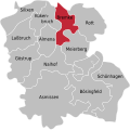 Extertal LIP Bremke.svg 563 × 561; 136 KB
 Extertal LIP Bösingfeld.svg 563 × 561; 136 KB
 Extertal LIP Göstrup.svg 563 × 561; 136 KB
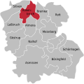 Extertal LIP Kükenbruch.svg 563 × 561; 136 KB
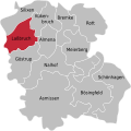 Extertal LIP Laßbruch.svg 563 × 561; 136 KB
 Extertal LIP Meierberg.svg 563 × 561; 136 KB
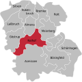 Extertal LIP Nalhof.svg 563 × 561; 136 KB
 Extertal LIP Ortsteile 2.svg 563 × 561; 136 KB
 Extertal LIP Ortsteile.svg 131 × 129; 1.23 MB
 Extertal LIP Rott.svg 563 × 561; 136 KB
 Extertal LIP Schönhagen.svg 563 × 561; 136 KB
 Extertalbahn.jpg 621 × 621; 407 KB
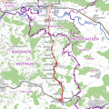 Extertalbahn.svg 621 × 621; 4.07 MB
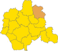 Lokal Ort Extertal.png 288 × 251; 9 KB
 North rhine w lip Extertal.png 921 × 820; 417 KB
 Extertal LIP Silixen.svg 563 × 561; 136 KB


