Category:Maps of Dong Thap
Jump to navigation
Jump to search
Media in category "Maps of Dong Thap"
The following 14 files are in this category, out of 14 total.
-
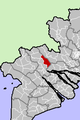
 Cao Lanh City.png 200 × 301; 8 KB
-
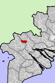
 Cao Lanh District.png 200 × 301; 8 KB
-
 Chau Thanh District DT.png 200 × 301; 8 KB
-
 Dongthap.jpg 1,369 × 1,883; 943 KB
-
 Hong Ngu District.png 200 × 301; 8 KB
-
 Lai Vung District.png 200 × 301; 8 KB
-
 Lap Vo District.png 200 × 301; 8 KB
-
 Long Xuyen Province 1886.jpg 7,605 × 11,135; 17.42 MB
-
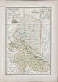 Province de Sadec (1909).jpg 3,229 × 4,525; 2.25 MB
-
 Sa Dec District.png 200 × 301; 8 KB
-
 Tam Nong District.png 200 × 301; 8 KB
-
 Tan Hong District.png 200 × 301; 8 KB
-
 Thanh Binh District.png 200 × 301; 8 KB
-
 Thap Muoi District.png 200 × 301; 8 KB


.jpg)


