Category:Maps of Cudillero
Jump to navigation
Jump to search
Municipalities in Asturias: Allande · Aller · Amieva · Avilés · Belmonte de Miranda · Bimenes · Boal · Cabrales · Cabranes · Candamo · Cangas de Onís · Cangas del Narcea · Caravia · Carreño · Caso · Castrillón · Castropol · Coaña · Colunga · Corvera · Cudillero · Degaña · El Franco · El Valle Altu de Peñamellera · Gijón · Gozón · Grado · Grandas de Salime · Ibias · Illano · Illas · Langreo · Laviana · Lena · Llanera · Llanes · Mieres · Oviedo · Parres · Piloña · Ribadesella · Salas · San Martín del Rey Aurelio · Somiedo · Taramundi · Teverga · Tineo · Vegadeo · Villanueva de Oscos · Villaviciosa · Villayón · Yernes y Tameza ·
Media in category "Maps of Cudillero"
The following 10 files are in this category, out of 10 total.
-
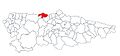
 Cudillero.png 454 × 181; 6 KB
-
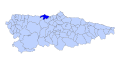
 Cuideiru (situación).jpg 750 × 350; 50 KB
-
 Cuideiru Asturies map.svg 778 × 413; 292 KB
-
 Karte Gemeinde Cudillero 2022.png 2,999 × 1,804; 617 KB
-
 Mapa parroquial de Cuideiru, dixebráu por colores..jpg 625 × 400; 64 KB
-
 Mapa parroquial de Cuideiru.jpg 625 × 400; 56 KB
-
 MTN25-0012c4-2014-Riegoabajo.jpg 7,023 × 5,168; 21.05 MB
-
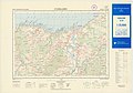 MTN25-0013c3-1980-Cudillero.jpg 7,775 × 5,413; 6.98 MB
-
 MTN25-0013c3-1998-Cudillero.jpg 7,775 × 5,413; 7.4 MB
-
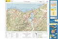 MTN25-0013c3-2015-Cudillero.jpg 7,579 × 5,143; 21.05 MB
.jpg)


