Category:Maps of Cromer
Jump to navigation
Jump to search

Wikimedia category | |||||
| Upload media | |||||
| Instance of | |||||
|---|---|---|---|---|---|
| Category combines topics | |||||
| Cromer | |||||
town in Norfolk, England  | |||||
| Instance of | |||||
| Location | North Norfolk, Norfolk, East of England, England | ||||
| Population |
| ||||
| Area |
| ||||
| Said to be the same as | Cromer (Wikimedia duplicated page, civil parish) | ||||
| official website | |||||
 | |||||
Media in category "Maps of Cromer"
The following 17 files are in this category, out of 17 total.
-
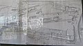 -2019-09-20 Layout plans of Cromer Beach station.JPG 4,723 × 2,583; 2.28 MB
-
 -2022-03-01 Map of North Lodge Park (1895), Cromer, Norfolk.JPG 2,576 × 4,326; 1.8 MB
-
-
 Admiralty Chart No 1408 Harwich to Terschelling and Cromer to Rotterdam, Published 1958.jpg 16,347 × 11,272; 47.22 MB
-

-
 Admiralty Chart No 1630 England - east coast Orfordness to Cromer RMG L1186, Published 1874.tiff 8,827 × 12,257; 309.54 MB
-
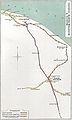
 Cromer stations.PNG 579 × 392; 29 KB
-
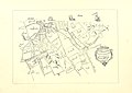
 Cromer, North Walsham & Runton RJD 153.jpg 1,597 × 2,653; 484 KB
-
 Dune heterogeneity Rotliegendes HydeField.jpg 720 × 540; 133 KB
-
 Hasiboro sands chart 13 02 2010.JPG 4,000 × 3,000; 2.34 MB
-
 Norfolk outline map Cromer.png 722 × 492; 328 KB
-
 Ordnance Survey One-Inch Sheet 126 Norwich, Published 1945.jpg 10,917 × 12,845; 13.74 MB
-
 Ordnance Survey One-Inch Sheet 126 Norwich, Published 1954.jpg 8,354 × 9,977; 8.89 MB
-
 Ordnance Survey One-Inch Sheet 126 Norwich, Published 1969.jpg 8,290 × 9,862; 29.26 MB
-
 Ordnance Survey One-Inch Sheet 58 Cromer, Published 1922.jpg 12,210 × 8,487; 8.2 MB
-
 Ordnance Survey Sheet TG 14 24 Sheringham, Published 1956.jpg 8,345 × 5,624; 20.01 MB
-
 OS Map of North Norfolk (1816), Norfolk, England.jpg 4,000 × 2,127; 2.82 MB

,_Cromer,_Norfolk.JPG)
.jpg)


,_Norfolk,_England.jpg)