Category:Maps of Creissels (Aveyron)
Jump to navigation
Jump to search
Media in category "Maps of Creissels (Aveyron)"
The following 11 files are in this category, out of 11 total.
-
 12084-Creissels-Arron.png 3,057 × 2,480; 1.23 MB
-
 12084-Creissels-cadastre.svg 961 × 744; 4.29 MB
-
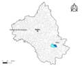 12084-Creissels-Canton.png 3,057 × 2,480; 1.25 MB
-
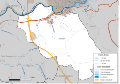
 12084-Creissels-EPCI.png 3,057 × 2,480; 1.25 MB
-
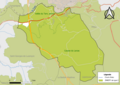
 12084-Creissels-Hydro.png 3,519 × 2,480; 1.9 MB
-
 12084-Creissels-Natura2000.png 7,039 × 4,960; 3.47 MB
-
 12084-Creissels-Sols.png 3,507 × 2,480; 2.21 MB
-
 12084-Creissels-ZNIEFF1.png 3,519 × 2,480; 1.6 MB
-
 12084-Creissels-ZNIEFF2.png 3,519 × 2,480; 1.37 MB
-
 12084-Creissels-Zone inondable.svg 1,070 × 744; 2.7 MB
-
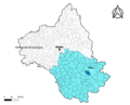
 Map commune FR insee code 12084.png 756 × 605; 65 KB


