Category:Maps of Constantine (Algeria)
Jump to navigation
Jump to search
Français : Cartes de Constantine (Algérie)
Media in category "Maps of Constantine (Algeria)"
The following 13 files are in this category, out of 13 total.
-
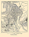
 AFR V2 D304 Constantine in 1836.jpg 1,733 × 2,280; 759 KB
-
 Carte Hachette Joanne-1887-Plan de Constantine.jpg 4,206 × 5,306; 8.68 MB
-
 Constantine location.png 175 × 172; 14 KB
-
 Constantine location.svg 429 × 425; 9 KB
-
 DZ-25-01 Constantine.svg 1,100 × 980; 55 KB
-
 DZ-2501.svg 744 × 535; 74 KB
-
 ETH-BIB-Constantine-Rummelschlucht, Karte-Dia 247-Z-00106.tif 2,921 × 3,442; 28.91 MB
-
 France & Colonies-1894-Constantine.jpg 2,657 × 3,415; 3.03 MB
-
 Map of Constantine Algeria 1940s.jpg 5,964 × 4,351; 6.86 MB
-
 Map of the tramway system in Constantine, Algeria.png 958 × 969; 900 KB
-
 Meyer‘s Zeitungsatlas 044 – Marocco, Algier und Tunis.jpg 7,420 × 6,224; 10.96 MB
-
 Plan der Stadt Constantine.jpg 5,924 × 3,906; 6.2 MB
-


.jpg)