Category:Maps of Congo (DR) by User:Milenioscuro
Jump to navigation
Jump to search
Media in category "Maps of Congo (DR) by User:Milenioscuro"
The following 5 files are in this category, out of 5 total.
-
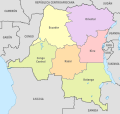 Congo DemRep, administrative divisions - es - colored (1960).svg 1,150 × 1,095; 426 KB
-
 Congo DemRep, administrative divisions - es - colored (1988).svg 1,150 × 1,095; 481 KB
-
 Congo DemRep, administrative divisions - es - colored (2015).svg 1,150 × 1,095; 907 KB
-
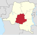 Kasai in Democratic Republic of the Congo.svg 1,150 × 1,095; 330 KB
-
 Kivu in Democratic Republic of the Congo.svg 1,150 × 1,095; 330 KB
.svg)
.svg)
.svg)

