Category:Maps of Chin State
Jump to navigation
Jump to search
Media in category "Maps of Chin State"
The following 32 files are in this category, out of 32 total.
-
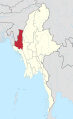
 Burma Chin locator map.png 1,000 × 2,100; 475 KB
-
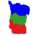
 Chin state district map 2022.svg 410 × 781; 107 KB
-
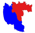
 Chin state district map.svg 630 × 644; 105 KB
-
 Chin State in Myanmar 2010.svg 1,228 × 2,003; 985 KB
-
 Chin State in Myanmar.svg 1,200 × 2,520; 1.2 MB
-
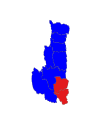
 District Map of Chin State.png 570 × 1,197; 210 KB
-
 Falam district 2022.svg 1,001 × 795; 16 KB
-
 Falam district in Chin state 2022.svg 410 × 781; 107 KB
-
 Falam district in Chin state.svg 1,093 × 1,259; 105 KB
-
 Falam district.svg 383 × 390; 30 KB
-
 Falam tsp in Flam district.svg 236 × 264; 30 KB
-
 Hakha district in Chin state.svg 734 × 863; 105 KB
-
 Hakha tsp in Hakha district.svg 532 × 485; 27 KB
-
 Kanpetlet tsp in Mindat district.svg 809 × 744; 24 KB
-
 Matupi district in Chin state 2022.svg 410 × 781; 107 KB
-
 Matupi district in Chin state.svg 867 × 742; 105 KB
-
 Matupi district.svg 493 × 461; 25 KB
-
 Matupi tsp in Matupi district.svg 512 × 490; 44 KB
-
 Mindat district in Chin state.svg 655 × 722; 105 KB
-
 Mindat tsp in Mindat district.svg 663 × 606; 25 KB
-
 Paletwa district in Chin state.svg 410 × 781; 107 KB
-
 Paletwa district.svg 428 × 573; 28 KB
-
 Paletwa tsp in Matupi district.svg 634 × 631; 44 KB
-
 Senthang Map.jpg 1,203 × 1,320; 1.97 MB
-
 Tedim District Map.jpg 3,024 × 3,389; 2.18 MB
-
 Tedim District.jpg 11,381 × 13,119; 3.58 MB
-
 Tedim district.svg 177 × 201; 22 KB
-
 Tedim tsp in Falam district.svg 236 × 264; 30 KB
-
 Teedim district in Chin state.svg 410 × 781; 107 KB
-
 Thantlang tsp in Hakha district.svg 679 × 559; 27 KB
-
 Tonzang tsp in Falam district.svg 596 × 611; 30 KB
-
 Tonzang tsp in Tedim district.svg 177 × 201; 22 KB


