Category:Maps of Cheverny (Loir-et-Cher)
Jump to navigation
Jump to search
Media in category "Maps of Cheverny (Loir-et-Cher)"
The following 7 files are in this category, out of 7 total.
-
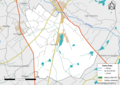
 41050-Cheverny-Natura2000-SIC.png 3,507 × 2,480; 1.62 MB
-
 41050-Cheverny-Natura2000-ZPS.png 3,507 × 2,480; 1.53 MB
-
 41067-Cour-Cheverny-Natura2000-SIC.png 3,507 × 2,480; 1.81 MB
-
 41067-Cour-Cheverny-Natura2000-ZPS.png 3,507 × 2,480; 1.71 MB
-
 Localisation de Cheverny.jpg 562 × 462; 20 KB
-
 Map commune FR insee code 41050.png 756 × 605; 68 KB
-
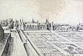 Veüe de la Maison de Chivergni - Dessin d'Étienne Martellange - ca 1624 (adjusted).jpg 4,778 × 3,226; 3.86 MB


.jpg)