Category:Maps of Cambrai city walls
Jump to navigation
Jump to search
Subcategories
This category has only the following subcategory.
M
Media in category "Maps of Cambrai city walls"
The following 13 files are in this category, out of 13 total.
-
 Plan de Cambrai 1693.jpg 6,433 × 5,018; 3.04 MB
-
 Upload 2021-08-08 10.jpg 4,127 × 3,768; 2.96 MB
-
 Partie du plan de Cambrai levée en 1753.jpg 15,075 × 9,089; 21.06 MB
-
 Plan de Cambrai 1783.jpg 11,950 × 7,730; 14.24 MB
-
 Plan de Cambrai relatif aux projets de 1787 pour 1788.jpg 9,520 × 5,964; 7.09 MB
-
 Plan de Cambrai 17xx.jpg 11,376 × 7,336; 12.64 MB
-
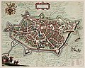
 Atlas de Wit 1698-pl084-Kamerijk (Cambrai)-KB PPN 145205088.jpg 2,000 × 1,644; 1.64 MB
-
 Barbacane.chateau.Cantimpre.Cambrai.png 445 × 504; 44 KB
-
 Cambrai - Cameracvm vulgo Cambray - Kamerijk (Atlas van Loon).jpg 5,500 × 4,405; 3.6 MB
-
 De merian Westphaliae 139.jpg 3,588 × 2,520; 2.14 MB
-
 Fotothek df tg 0002911 Architektur ^ Festungsbau ^ Zitadelle.jpg 644 × 820; 257 KB
-
 Map of Cambrai 1710.jpg 1,884 × 1,350; 841 KB
-
 Perspective de Cambrai.jpg 8,648 × 5,632; 8.07 MB


-KB_PPN_145205088.jpg)

.jpg)


