Category:Maps of Butler County, Kansas
Jump to navigation
Jump to search
Counties of Kansas: Allen · Anderson · Atchison · Barber · Barton · Bourbon · Brown · Butler · Chase · Chautauqua · Cherokee · Cheyenne · Clark · Clay · Cloud · Coffey · Comanche · Cowley · Crawford · Decatur · Dickinson · Doniphan · Douglas · Edwards · Elk · Ellis · Ellsworth · Finney · Ford · Franklin · Geary · Gove · Graham · Grant · Gray · Greeley · Greenwood · Hamilton · Harper · Harvey · Haskell · Hodgeman · Jackson · Jefferson · Jewell · Johnson · Kearny · Kingman · Kiowa · Labette · Lane · Leavenworth · Lincoln · Linn · Logan · Lyon · Marion · Marshall · McPherson · Meade · Miami · Mitchell · Montgomery · Morris · Morton · Nemaha · Neosho · Ness · Norton · Osage · Osborne · Ottawa · Pawnee · Phillips · Pottawatomie · Pratt · Rawlins · Reno · Republic · Rice · Riley · Rooks · Rush · Russell · Saline · Scott · Sedgwick · Seward · Shawnee · Sheridan · Sherman · Smith · Stafford · Stanton · Stevens · Sumner · Thomas · Trego · Wabaunsee · Wallace · Washington · Wichita · Wilson · Woodson · Wyandotte
Wikimedia category | |||||
| Upload media | |||||
| Instance of | |||||
|---|---|---|---|---|---|
| Category combines topics | |||||
| Butler County | |||||
county in Kansas, United States   | |||||
| Instance of | |||||
| Named after | |||||
| Location | Kansas | ||||
| Capital | |||||
| Inception |
| ||||
| Population |
| ||||
| Area |
| ||||
| Different from | |||||
| official website | |||||
 | |||||
Media in category "Maps of Butler County, Kansas"
The following 70 files are in this category, out of 70 total.
-

-

-

-
-

-

-

-

-
 Butler County Kansas Incorporated and Unincorporated areas Leon Highlighted.svg 1,000 × 600; 118 KB
-
-

-

-

-
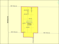
 Detailed map of Andover, Kansas.png 575 × 425; 36 KB
-
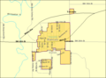
 Detailed map of Augusta, Kansas.png 575 × 425; 40 KB
-
 Detailed map of Benton, Kansas.png 575 × 425; 13 KB
-
 Detailed map of Cassoday, Kansas.png 575 × 425; 14 KB
-
 Detailed map of Douglass, Kansas.png 575 × 425; 22 KB
-
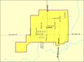
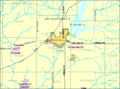 Detailed map of El Dorado, Kansas.png 575 × 425; 31 KB
-
 Detailed map of Elbing, Kansas.png 575 × 425; 9 KB
-
 Detailed map of Latham, Kansas.png 575 × 425; 13 KB
-
 Detailed map of Leon, Kansas.png 575 × 425; 15 KB
-
 Detailed map of Potwin, Kansas.png 575 × 425; 15 KB
-
 Detailed map of Rose Hill, Kansas.png 575 × 425; 25 KB
-
 Detailed map of Towanda, Kansas.png 575 × 425; 21 KB
-
 Detailed map of Whitewater, Kansas.png 575 × 425; 17 KB
-
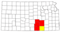
 Kansas Senate District 14 (2010).png 3,507 × 2,190; 317 KB
-
 Kansas Senate District 16 (2010).png 3,507 × 2,190; 312 KB
-
 KSMap-doton-Andover.png 300 × 156; 8 KB
-
 KSMap-doton-Augusta.png 300 × 156; 8 KB
-
 KSMap-doton-Benton.png 300 × 156; 8 KB
-
 KSMap-doton-Douglass.png 300 × 156; 8 KB
-
 KSMap-doton-El Dorado.png 300 × 156; 8 KB
-
 KSMap-doton-Elbing.png 300 × 156; 8 KB
-
 KSMap-doton-Latham.png 300 × 156; 8 KB
-
 KSMap-doton-Leon.png 300 × 156; 8 KB
-
 KSMap-doton-Potwin.png 300 × 156; 8 KB
-
 KSMap-doton-Whitewater.png 300 × 156; 8 KB
-
 Map highlighting Augusta Township, Butler County, Kansas.svg 512 × 512; 58 KB
-
 Map highlighting Benton Township, Butler County, Kansas.svg 512 × 512; 73 KB
-
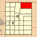
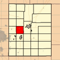
 Map highlighting Bloomington Township, Butler County, Kansas.svg 512 × 512; 90 KB
-
 Map highlighting Bruno Township, Butler County, Kansas.svg 512 × 512; 108 KB
-
 Map highlighting Chelsea Township, Butler County, Kansas.svg 512 × 512; 122 KB
-
 Map highlighting Clay Township, Butler County, Kansas.svg 512 × 512; 138 KB
-
 Map highlighting Clifford Township, Butler County, Kansas.svg 512 × 512; 155 KB
-
 Map highlighting Douglass Township, Butler County, Kansas.svg 512 × 512; 170 KB
-
 Map highlighting El Dorado Township, Butler County, Kansas.svg 512 × 512; 204 KB
-
 Map highlighting Fairmount Township, Butler County, Kansas.svg 512 × 512; 202 KB
-
 Map highlighting Fairview Township, Butler County, Kansas.svg 512 × 512; 220 KB
-
 Map highlighting Glencoe Township, Butler County, Kansas.svg 512 × 512; 234 KB
-
 Map highlighting Hickory Township, Butler County, Kansas.svg 512 × 512; 251 KB
-
 Map highlighting Lincoln Township, Butler County, Kansas.svg 512 × 512; 269 KB
-
 Map highlighting Little Walnut Township, Butler County, Kansas.svg 512 × 512; 285 KB
-
 Map highlighting Logan Township, Butler County, Kansas.svg 512 × 512; 300 KB
-
 Map highlighting Milton Township, Butler County, Kansas.svg 512 × 512; 316 KB
-
 Map highlighting Murdock Township, Butler County, Kansas.svg 512 × 512; 334 KB
-
 Map highlighting Pleasant Township, Butler County, Kansas.svg 512 × 512; 347 KB
-
 Map highlighting Plum Grove Township, Butler County, Kansas.svg 512 × 512; 364 KB
-
 Map highlighting Prospect Township, Butler County, Kansas.svg 512 × 512; 389 KB
-
 Map highlighting Richland Township, Butler County, Kansas.svg 512 × 512; 396 KB
-
 Map highlighting Rock Creek Township, Butler County, Kansas.svg 512 × 512; 411 KB
-
 Map highlighting Rosalia Township, Butler County, Kansas.svg 512 × 512; 428 KB
-
 Map highlighting Spring Township, Butler County, Kansas.svg 512 × 512; 448 KB
-
 Map highlighting Sycamore Township, Butler County, Kansas.svg 512 × 512; 462 KB
-
 Map highlighting Towanda Township, Butler County, Kansas.svg 512 × 512; 481 KB
-
 Map highlighting Union Township, Butler County, Kansas.svg 512 × 512; 495 KB
-
 Map highlighting Walnut Township, Butler County, Kansas.svg 512 × 512; 510 KB
-
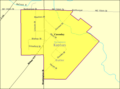
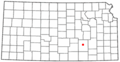
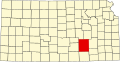
 Map of Butler Co, Ks, USA.png 1,004 × 1,122; 437 KB
-
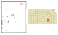
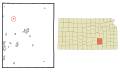
 Map of Kansas highlighting Butler County.svg 2,202 × 1,129; 21 KB
-
 Wichita-Winfield CSA.png 567 × 308; 18 KB


.png)
.png)


