Category:Maps of Budapest District VIII
Jump to navigation
Jump to search
Districts of Budapest: District I · District II · District III · District IV · District V · District VI · District VII · District VIII · District IX · District X · District XI · District XII · District XIII · District XIV · District XV · District XVI · District XVII · District XVIII · District XIX · District XX · District XXI · District XXII · District XXIII ·
Wikimedia category | |||||
| Upload media | |||||
| Instance of | |||||
|---|---|---|---|---|---|
| Category combines topics | |||||
| Budapest District VIII | |||||
district in Budapest | |||||
| Instance of | |||||
| Location | Budapest, Hungary | ||||
| School district |
| ||||
| Head of government |
| ||||
| Has part(s) |
| ||||
| Inception |
| ||||
| Population |
| ||||
| Area |
| ||||
| Follows | |||||
| Followed by | |||||
| official website | |||||
 | |||||
Media in category "Maps of Budapest District VIII"
The following 12 files are in this category, out of 12 total.
-
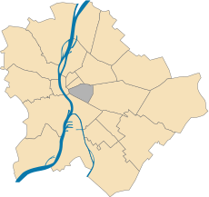
Budapest Bezirk08.svg 600 × 566; 87 KB
-
Budapest District 8 Municipal Constituencies 2024.svg 2,331 × 1,629; 6.26 MB
-
Budapest District 8 Precincts 2024.svg 2,331 × 1,629; 6.35 MB
-
Budapest district08.svg 740 × 707; 11.81 MB
-
Hungary budapest district 8.jpg 564 × 537; 73 KB
-
Hungary budapest district 8.svg 562 × 537; 15 KB
-
Ludovica Academy street map 1884.jpg 482 × 600; 222 KB
-
Magdolna-negyed map.svg 1,163 × 781; 160 KB
-
Map budapest district8.svg 251 × 251; 156 KB
-
Map. - Orczy garden, Budapest District VIII.JPG 2,272 × 1,704; 1.05 MB
-
MTK-pálya bontás előtt IV 2014. augusztus 31.jpg 2,680 × 1,748; 4.55 MB
-
Palotanegyed 1896.jpg 640 × 471; 136 KB


