Category:Maps of Bedford Park, Bronx
Jump to navigation
Jump to search
Media in category "Maps of Bedford Park, Bronx"
The following 33 files are in this category, out of 33 total.
-

-
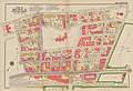
 Bromley Bronx Plate 24 publ. 1938 corr. 1957.jpg 9,643 × 6,514; 15.75 MB
-
 Bromley Bronx Plate 24 publ. 1938.jpg 9,021 × 6,161; 13.79 MB
-
 Bromley Bronx Plate 25 publ. 1938 corr. 1957.jpg 9,666 × 6,603; 15.69 MB
-
 Bromley Bronx Plate 25 publ. 1938.jpg 9,105 × 6,242; 14.02 MB
-
 Bromley Bronx Plate 26 publ. 1938.jpg 9,078 × 6,212; 14.13 MB
-
 Bromley Bronx Plate 27 publ. 1938 corr. 1957.jpg 9,327 × 6,760; 12.12 MB
-
 Bromley Bronx Plate 27 publ. 1938.jpg 8,730 × 6,277; 10.81 MB
-
 Bromley Bronx volume index publ. 1938.jpg 8,615 × 5,920; 14.02 MB
-
 Bronx, V. 13, Plate No. 38 (Map bounded by Briggs Ave., E. 200th St., Webster Ave., E. 198th St.) NYPL2002824.tiff 6,712 × 8,957, 2 pages; 172.06 MB
-
 Bronx, V. 14, Plate No. 58 (Map bounded by Bedford Park Blvd., Briggs Ave., E. 198th St., Grand Blvd.) NYPL2003010.tiff 6,693 × 8,932, 2 pages; 171.1 MB
-
 Bronx, V. 14, Plate No. 59 (Map bounded by Bedford Park Blvd., E. 198th St., Briggs Ave.) NYPL2003011.tiff 6,730 × 8,981, 2 pages; 172.99 MB
-
 Bronx, V. 14, Plate No. 60 (Map bounded by Bedford Park Blvd., E. 198th St., Marion Ave.) NYPL2003012.tiff 6,693 × 8,932, 2 pages; 171.1 MB
-
 Bronx, V. 14, Plate No. 62 (Map bounded by Grand Blvd., E. 202nd St., Bainbridge Ave.) NYPL2003014.tiff 6,693 × 8,932, 2 pages; 171.1 MB
-
 Bronx, V. 14, Plate No. 63 (Map bounded by Bainbridge Ave., E. 201st St., Webster Ave., Bedford Park Blvd.) NYPL2003015.tiff 6,709 × 8,953, 2 pages; 171.91 MB
-
 Bronx, V. 14, Plate No. 64 (Map bounded by E. 204th St., Bedford Park Blvd., Webster Ave.) NYPL2003016.tiff 6,681 × 8,916, 2 pages; 170.49 MB
-
 Bronx, V. 14, Plate No. 65 (Map bounded by Grand Blvd., E. 205th St., E. Mosholu Parkway South, E. 202nd St.) NYPL2003017.tiff 6,709 × 8,953, 2 pages; 171.91 MB
-
 Bronx, V. 14, Plate No. 66 (Map bounded by E. Mosholu Parkway North, E. 201st St.., Briggs Ave.) NYPL2003018.tiff 6,690 × 8,928, 2 pages; 170.95 MB
-
 Bronx, V. 14, Plate No. 67 (Map bounded by Perry Ave., E. Mosholu Parkway North, Webster Ave., E. 201st St.) NYPL2003019.tiff 6,723 × 8,972, 2 pages; 172.63 MB
-
 Bronx, V. 2, Double Page Plate No. 27 (Map bounded by Briggs Ave., Mosholu Parkway S., Bronx Park, E. 196th St.) NYPL2020936.tiff 7,160 × 5,370, 2 pages; 110.07 MB
-
 Bronx, V. 2, Double Page Plate No. 28 (Map bounded by Jerome Park Reservoir, E. 204th St., E. 202nd St., Briggs Ave.) NYPL2020937.tiff 7,191 × 5,393, 2 pages; 111.01 MB
-
 Bronx, V. 2, Double Page Plate No. 30 (Map bounded by E. 208th St., Bainbridge Ave., 202nd St., Jerome Park Reservoir) NYPL2020939.tiff 7,191 × 5,393, 2 pages; 111.01 MB
-

-

-

-
 Hyde V. 2 Plate 30 publ. 1901.jpg 7,230 × 5,428; 30.86 MB
-
 Hyde V. 2 Plate 34 publ. 1901.jpg 7,230 × 5,428; 30.61 MB
-
 Hyde V. 2 Plate 35 publ. 1901.jpg 7,230 × 5,428; 32.59 MB
-
 Key continued NYPL2002786.tiff 6,723 × 8,972, 2 pages; 172.63 MB
-
 Key NYPL2002951.tiff 6,695 × 8,934, 2 pages; 171.19 MB
-
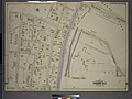
 Robinson Manhattan and Bronx Plate 40 publ. 1885.jpg 6,033 × 4,052; 35.36 MB
-
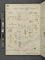
 Sanborn Bronx V. 12 Plate 276 publ. 1896.jpg 8,090 × 5,901; 5.7 MB
-
 Sanborn V. 13 Plate 38 publ. 1900.jpg 6,712 × 8,957; 46.19 MB
_-_Bronx_County_-_Bronx_County_-_ED_3-1_to_2101_-_NARA_-_24066691_(page_3).jpg)


