Category:Maps of Balaton
Jump to navigation
Jump to search
Wikimedia category | |||||
| Upload media | |||||
| Instance of | |||||
|---|---|---|---|---|---|
| Category combines topics | |||||
| Lake Balaton | |||||
freshwater lake in Hungary   | |||||
| Instance of |
| ||||
| Location |
| ||||
| Heritage designation |
| ||||
| Width |
| ||||
| Length |
| ||||
| Coastline |
| ||||
| Area |
| ||||
| Elevation above sea level |
| ||||
| Inflows |
| ||||
| Outflows | |||||
| Drainage basin | |||||
| Basin country | |||||
| Different from | |||||
 | |||||
Subcategories
This category has the following 2 subcategories, out of 2 total.
L
- Lake Balaton Offensive (9 F)
O
- Old maps of Balaton (5 F)
Media in category "Maps of Balaton"
The following 18 files are in this category, out of 18 total.
-
 Akarattyai Rákóczi-fa.png 1,000 × 1,000; 40 KB
-
 Ancient balaton.jpg 800 × 588; 66 KB
-
 Balaton Karte.png 2,500 × 1,887; 5 MB
-
 Balaton.jpeg 1,024 × 768; 233 KB
-
 Balaton.png 579 × 353; 42 KB
-
 Balaton.svg 630 × 330; 9 KB
-
 Balatonfured Map.jpg 615 × 388; 19 KB
-
 Lago Balaton mappa it.png 429 × 298; 179 KB
-
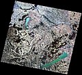 Landsat-5 felvétele az Észak-Dunántúlról.jpg 1,199 × 1,102; 335 KB
-
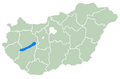 Location of Balaton.PNG 301 × 198; 5 KB
-
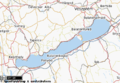
 Map of Balaton.png 785 × 520; 45 KB
-
 Pápa - 35-47.jpg 3,462 × 4,932; 4.59 MB
-
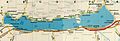 Régi Balaton térkép.jpg 1,407 × 481; 199 KB
-
 Révai nagy lexikona; az ismeretek enciklopédiája (1911) (14597986749).jpg 3,232 × 2,018; 1.04 MB
-
 Straße 84, Unterführung, Balaton, 2021 Sümeg.jpg 2,084 × 1,564; 582 KB
-
 Székesfehérvár - 36-47.jpg 3,443 × 4,968; 4.39 MB
-
 Veszprem county map.jpg 2,100 × 1,665; 485 KB
-
 Zala county map.jpg 2,200 × 1,600; 489 KB


_(14597986749).jpg)


