Category:Maps of Awaji Island
Jump to navigation
Jump to search
Media in category "Maps of Awaji Island"
The following 10 files are in this category, out of 10 total.
-
 Admiralty Chart No 3566 Izumi Nada to Harima Nada, Published 1906, New Edition 1915.jpg 16,160 × 11,123; 68.95 MB
-
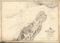 Admiralty Chart No 93 Akashi No-Seto, Published 1870.jpg 10,870 × 7,918; 28.96 MB
-
 Awaji-is.png 149 × 150; 1 KB
-
 Awaji-island.png 314 × 372; 7 KB
-
 Awajishima Relief Map, SRTM.jpg 1,200 × 1,600; 562 KB
-
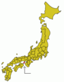 Japan prov map awaji.png 235 × 300; 6 KB
-
 Location-of-Awaji-island-en.png 640 × 480; 95 KB
-
 Location-of-Awaji-island-ja.png 640 × 480; 96 KB
-
 OSM Awaji shima Japan.png 2,398 × 1,627; 4.4 MB
-
 Prefectures of Japan Awaji - Copy.png 678 × 898; 53 KB


