Category:Maps of Audubon County, Iowa
Jump to navigation
Jump to search
Counties of Iowa: Adair · Adams · Allamakee · Appanoose · Audubon · Benton · Black Hawk · Boone · Bremer · Buchanan · Buena Vista · Butler · Calhoun · Carroll · Cass · Cedar · Cerro Gordo · Cherokee · Chickasaw · Clarke · Clay · Clayton · Clinton · Crawford · Dallas · Davis · Decatur · Delaware · Des Moines · Dickinson · Dubuque · Emmet · Fayette · Floyd · Franklin · Fremont · Greene · Grundy · Guthrie · Hamilton · Hancock · Hardin · Harrison · Henry · Howard · Humboldt · Ida · Iowa · Jackson · Jasper · Jefferson · Johnson · Jones · Keokuk · Kossuth · Lee · Linn · Louisa · Lucas · Lyon · Madison · Mahaska · Marion · Marshall · Mills · Mitchell · Monona · Monroe · Montgomery · Muscatine · O'Brien · Osceola · Page · Palo Alto · Plymouth · Pocahontas · Polk · Pottawattamie · Poweshiek · Ringgold · Sac · Scott · Shelby · Sioux · Story · Tama · Taylor · Union · Van Buren · Wapello · Warren · Washington · Wayne · Webster · Winnebago · Winneshiek · Woodbury · Worth · Wright
Wikimedia category | |||||
| Upload media | |||||
| Instance of | |||||
|---|---|---|---|---|---|
| Category combines topics | |||||
| Audubon County | |||||
county in Iowa, United States   | |||||
| Instance of | |||||
| Named after | |||||
| Location | Iowa | ||||
| Capital | |||||
| Inception |
| ||||
| Population |
| ||||
| Area |
| ||||
| official website | |||||
 | |||||
Subcategories
This category has only the following subcategory.
Media in category "Maps of Audubon County, Iowa"
The following 26 files are in this category, out of 26 total.
-

-

-

-

-
-
 Audubon County Iowa.png 300 × 194; 9 KB
-
 Audubon County, Iowa 1903.png 437 × 468; 563 KB
-
 Audubon County, Iowa, 1902.png 629 × 593; 979 KB
-
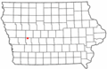
 IAMap-doton-Audubon.PNG 300 × 194; 12 KB
-
 IAMap-doton-Brayton.PNG 300 × 194; 12 KB
-
 IAMap-doton-Exira.PNG 300 × 194; 12 KB
-
 IAMap-doton-Gray.PNG 300 × 194; 12 KB
-
 IAMap-doton-Kimballton.PNG 300 × 194; 12 KB
-
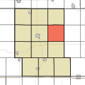
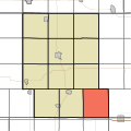 Map highlighting Audubon Township, Audubon County, Iowa.svg 512 × 512; 15 KB
-
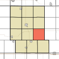
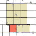
 Map highlighting Cameron Township, Audubon County, Iowa.svg 512 × 512; 15 KB
-
 Map highlighting Douglas Township, Audubon County, Iowa.svg 512 × 512; 15 KB
-
 Map highlighting Exira Township, Audubon County, Iowa.svg 512 × 512; 16 KB
-
 Map highlighting Greeley Township, Audubon County, Iowa.svg 512 × 512; 15 KB
-
 Map highlighting Hamlin Township, Audubon County, Iowa.svg 512 × 512; 15 KB
-
 Map highlighting Leroy Township, Audubon County, Iowa.svg 512 × 512; 15 KB
-
 Map highlighting Lincoln Township, Audubon County, Iowa.svg 512 × 512; 15 KB
-
 Map highlighting Melville Township, Audubon County, Iowa.svg 512 × 512; 15 KB
-
 Map highlighting Oakfield Township, Audubon County, Iowa.svg 512 × 512; 15 KB
-
 Map highlighting Sharon Township, Audubon County, Iowa.svg 512 × 512; 15 KB
-
 Map highlighting Viola Township, Audubon County, Iowa.svg 512 × 512; 15 KB
-
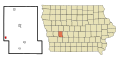
 Map of Iowa highlighting Audubon County.svg 1,783 × 1,168; 31 KB


