Category:Maps of A Illa de Ons
Jump to navigation
Jump to search
Media in category "Maps of A Illa de Ons"
The following 11 files are in this category, out of 11 total.
-
 Ar.E-T.4-C.6 269.jpg 1,418 × 1,927; 341 KB
-
 Hidrogalicia m ons.svg 800 × 800; 1.47 MB
-
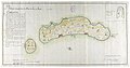
 Ilhas de Ons e Onça (1810).jpg 2,048 × 1,058; 179 KB
-
 Mapa da jurisdiçom da Lançada.jpg 737 × 957; 339 KB
-
 Mapa das Illas Ons.png 645 × 1,125; 110 KB
-
 Ons Rotas 3.PNG 473 × 543; 304 KB
-
 Parroquia da Illa de Ons, Bueu.png 996 × 617; 111 KB
-
 Plano da ria de Ponte Vedra coas ilhas Ons e Onça (1827).jpg 750 × 523; 106 KB
-
 Plano que manifesta as illas de Ons e Onza 1810.jpg 984 × 519; 368 KB
-
 Plano, Illa de Ons, Galicia, España.jpg 3,072 × 1,728; 1.26 MB
-
 Po-9-20.jpg 13,356 × 3,964; 4.1 MB


.jpg)


.jpg)

