Category:Maps of 6th-century Asia
Jump to navigation
Jump to search
Subcategories
This category has the following 4 subcategories, out of 4 total.
Media in category "Maps of 6th-century Asia"
The following 11 files are in this category, out of 11 total.
-
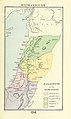
 MACCOUN(1899) p207 PALESTINE IN THE SIXTH CENTURY.jpg 2,022 × 3,606; 2.83 MB
-
-
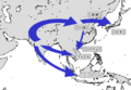
 Asia 600ad 2.jpg 1,984 × 1,276; 963 KB
-
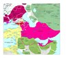
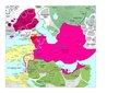
 Empire of the Gökturks.png 752 × 591; 39 KB
-
 MahayanaMap-ja.png 958 × 659; 57 KB
-
 Moyen-Orient en 500.pdf 1,752 × 1,239; 442 KB
-
 Moyen-Orient en 550.pdf 1,752 × 1,239; 454 KB
-
 Sakuhoutaisei Early 6C.png 500 × 400; 93 KB
-
 The invasion of Goguryeo.png 400 × 400; 70 KB
-
 北周・北斉・陳・後梁.PNG 757 × 606; 39 KB
-
 西魏・東魏・梁.PNG 757 × 606; 36 KB
_p207_PALESTINE_IN_THE_SIXTH_CENTURY.jpg)
%27_(11250242085).jpg)


