Category:Maps of Île de Noirmoutier
Jump to navigation
Jump to search
Subcategories
This category has only the following subcategory.
M
- Maps of Noirmoutier-en-l'Île (12 F)
Media in category "Maps of Île de Noirmoutier"
The following 15 files are in this category, out of 15 total.
-
-

-
 Admiralty Chart No 3215 Goulet de Fromantine to Pointe de St. Gildas, Published 1901.jpg 16,430 × 11,413; 33.32 MB
-
 Baai von Bourneuf.jpg 1,810 × 2,133; 1.01 MB
-
 Carte du démembrement de Noirmoutier (L’Épine et La Guérinière).svg 871 × 765; 70 KB
-
 Geologic map Noirmoutier FR.svg 1,770 × 1,340; 988 KB
-

-
 Ile du pilier.svg 513 × 513; 119 KB
-
 Ile du Pillier - btv1b53153159j.jpg 7,734 × 5,042; 3.4 MB
-
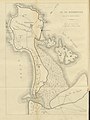
 Ile-de-Noirmoutier.png 652 × 800; 30 KB
-
 Mémoires de la Société géologique de France BHL42352677.jpg 5,470 × 2,968; 1.14 MB
-
 Noirmoutier carte.jpg 575 × 426; 62 KB
-
 Noirmoutier, Oléron, Perpignan, et Brest - btv1b55006075w (2 of 3).jpg 6,470 × 4,959; 2.68 MB
-
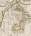
 Partie de la baye de Bourneuf-Masse (cropped).jpg 1,842 × 2,212; 1.25 MB
-
 Partie de la baye de Bourneuf-Masse.jpg 4,175 × 4,134; 3.53 MB
%27_(11122938333).jpg)


.svg)


.jpg)
.jpg)
