Category:Maps of Çanakkale Province
Jump to navigation
Jump to search
Wikimedia category | |||||
| Upload media | |||||
| Instance of | |||||
|---|---|---|---|---|---|
| Category combines topics | |||||
| Çanakkale Province | |||||
province of Turkey .svg)  | |||||
| Instance of | |||||
| Part of |
| ||||
| Location | Turkey | ||||
| Located in or next to body of water |
| ||||
| Capital | |||||
| Population |
| ||||
| official website | |||||
 | |||||
Subcategories
This category has the following 5 subcategories, out of 5 total.
Media in category "Maps of Çanakkale Province"
The following 26 files are in this category, out of 26 total.
-
 Canakkale Open Street Map Haritası.svg 965 × 828; 1.27 MB
-
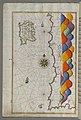
 Dardanelles and Gulf of Saros by Piri Reis.jpg 600 × 826; 176 KB
-
 Dardanelles defences 1915-es.svg 3,420 × 3,529; 322 KB
-
 Dardanelles defences 1915.png 600 × 620; 137 KB
-
 Dardanelles map2 tr.PNG 700 × 600; 383 KB
-
 Dardanelles map2.png 700 × 600; 123 KB
-
 Dardanelles mapgr.png 1,020 × 951; 279 KB
-
 Estrecho de Dardanelos-es.png 1,148 × 984; 266 KB
-
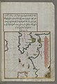
 Gelibolu by Piri Reis.jpg 1,667 × 2,184; 1.78 MB
-
 Gökçeada (İmroz) Etnik Haritası.png 1,200 × 626; 130 KB
-
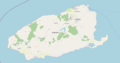 Gökçeada OpenStreetMap map.png 1,220 × 636; 107 KB
-
 Imbros Tenedos map location el.svg 725 × 674; 427 KB
-
 ImbrosTenedos 2-es.svg 725 × 674; 203 KB
-
 ImbrosTenedos 2.svg 725 × 674; 203 KB
-
 ImbrosTenedos HE.svg 725 × 674; 203 KB
-
 Locator map-Çanakkale Province.png 1,024 × 440; 143 KB
-
-

-
-
 Turkishstraits.jpg 6,237 × 4,188; 4.22 MB
-
 Vieux chateau d'Europe - Lemoyne - btv1b53100665g.jpg 4,496 × 3,056; 1.61 MB
-
 Çanakkale - btv1b101008340.jpg 6,741 × 5,254; 5.49 MB
-
 Çanakkale - btv1b101009296.jpg 9,318 × 7,688; 8.65 MB
-
 Çanakkale harita.svg 1,052 × 744; 42 KB
-
 Çanakkale topographic location map.png 606 × 559; 441 KB
-
 Çanakkale Turkey Provinces locator.jpg 600 × 280; 28 KB


_Etnik_Haritas%C4%B1.png)


_Off_the_Coast_of_Anatolia_-_Walters_W65843A_-_Full_Page.jpg)


