Category:Maps in the Cartoteca storica delle Marche
Jump to navigation
Jump to search
| Historical cartotheque of the Marche
|
|||
|---|---|---|---|
 |
|||
| Parent institution | Q54870911 | ||
| Location | |||
| Coordinates | | ||
| Established | 2001 | ||
| Authority file |
| ||
Subcategories
This category has only the following subcategory.
M
Media in category "Maps in the Cartoteca storica delle Marche"
The following 14 files are in this category, out of 14 total.
-
 01 - La Marca d'Ancona, Roma 1564 - Vincenzo Luchino.jpg 2,769 × 2,220; 1.58 MB
-
 03 - Ducatus Urbini Nova Et Exacta Descriptio, 1606 - Giovanni Battista Urints.jpg 2,738 × 2,192; 1.64 MB
-
 04 - Marca D'Ancona, 1620 - Giovanni Antonio Magini.jpg 2,810 × 2,191; 1.77 MB
-
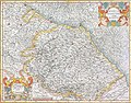
 05 - Ducato Di Urbino, 1620 - Giovanni Antonio Magini.jpg 2,859 × 2,175; 1.81 MB
-
 07 - Marchia Anconitana olim Picenum, 1635 - Henricus Hondius, Jan Jansson.jpg 2,806 × 2,207; 1.5 MB
-
 08 - Ducato di Urbino, 1635 - Henricus Hondius, Jan Jansson.jpg 2,827 × 2,207; 1.35 MB
-
 09 - Marca D'Ancona olim Picenum, 1640 - Willem Janszoon Blaeu.jpg 2,651 × 2,194; 1.5 MB
-
 10 - La Marca Anconitana E Fermana, 1699-1703, Silvestro Amanzio Moroncelli.jpg 2,697 × 2,222; 1.75 MB
-

-

-
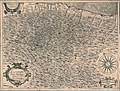
 13 - La Marca di Ancona Di nuova Projezione, 1779-1785 - Antonio Zatta.jpg 2,205 × 2,859; 1.57 MB
-
 14 - Die Mark Ancona, 1789-1806 - Franz Johann Joseph von Reilly.jpg 2,324 × 2,223; 1.1 MB
-
 15 - Carta della Marca di Fermo, Roma 1803 - Bernardino Olivieri.jpg 2,812 × 2,235; 1.34 MB
-
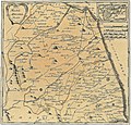
 16 - Carta Topografica del Dipartimento del Metauro, 1813 - Giuseppe Zani.jpg 2,525 × 2,240; 851 KB


