Category:Maps from Atlas de la historia física y política de Chile
Jump to navigation
Jump to search
Media in category "Maps from Atlas de la historia física y política de Chile"
The following 35 files are in this category, out of 35 total.
-
-

-

-

-

-

-

-

-

-

-

-

-

-

-
-

-

-

-

-
 Lago Pirehueico y Lacar en Atlas de Claudio Gay.jpg 4,032 × 3,024; 3.12 MB
-
 Lago Ranco en Atlas de Claudio Gay.jpg 4,032 × 3,024; 2.83 MB
-
 Lago Villarrica en Atlas de Claudio Gay.jpg 4,032 × 3,024; 3.14 MB
-
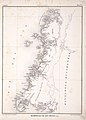
 Mapa provincia chiloe 1854.jpg 1,197 × 1,602; 652 KB
-
 Pelecahuín en Atlas de Claudio Gay.jpg 4,032 × 3,024; 1.94 MB
-
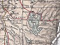
 Provincia de Aconcagua en Atlas de Claudio Gay.jpg 1,228 × 1,602; 601 KB
-
 Provincia de Valdivia en Atlas de Claudio Gay.jpg 4,032 × 3,024; 5.77 MB
-
 Provincias de Colchagua y Talca en Atlas de Claudio Gay.jpg 6,406 × 4,786; 4.59 MB
-
 Rio Cruces en el Plano de Arauco y Valdivia 1870.jpg 551 × 402; 89 KB
-
 Rio de San Pedro en el Plano de Arauco y Valdivia 1870.jpg 621 × 420; 97 KB
-
 Rio Tolten alto en el Plano de Arauco y Valdivia 1870.jpg 568 × 368; 89 KB
-
 Río Bueno en Atlas de Claudio Gay.jpg 4,032 × 3,024; 2.91 MB
-
 Río Bueno y La Unión.jpg 4,032 × 3,024; 5.3 MB
-
 Río Toltén en Atlas de Claudio Gay.jpg 4,032 × 3,024; 2.85 MB
-
 Río Valdivia en Atlas de Claudio Gay.jpg 4,032 × 3,024; 2.89 MB
-
 San Juan de la Costa en Atlas de Claudio Gay.jpg 4,032 × 3,024; 3.09 MB
.jpg)
.jpg)
.jpg)
.jpg)
.jpg)
.jpg)
.jpg)
.jpg)
.jpg)
.jpg)
.jpg)
.jpg)
.jpg)
.jpg)
.jpg)
.jpg)
.jpg)
.jpg)


