Category:Maps by William Heather
Jump to navigation
Jump to search
Subcategories
This category has only the following subcategory.
A
Media in category "Maps by William Heather"
The following 47 files are in this category, out of 47 total.
-
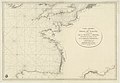
 A General Chart For the purpose of pricking off a Ship’s Track from England (15548000).jpg 45,053 × 20,882; 211.82 MB
-

-
 A new and improved chart of the West India or Carribbee islands - btv1b59708878.jpg 8,568 × 10,864; 10.35 MB
-
 A new and improved chart of the West India or Carribbee islands - btv1b5970888p.jpg 8,232 × 9,944; 9.07 MB
-
 A new and improved Mercator's chart of the Bay - W. Heather - btv1b53153705z.jpg 7,942 × 9,666; 7.46 MB
-
 A new and improved Mercator's chart of the Bay - W. Heather - btv1b53153706d.jpg 8,112 × 10,354; 8.92 MB
-
 A new chart of America with the harbors of New York, Boston, &c (2674864641).jpg 2,000 × 841; 1.45 MB
-
-
 A new chart of Guyana with the colonies of Cayenne, Surinam, & Trinadad (8250689368).jpg 2,000 × 1,637; 2.94 MB
-
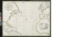
 A new chart of the Atlantic or Western Ocean (8345826935).jpg 799 × 606; 113 KB
-
-
 A new chart of the Azores or Western Isles (8250889280).jpg 2,000 × 1,620; 2.73 MB
-
-

-

-

-

-
 A New Chart of the Madeira and Canary Islands (8250888598).jpg 2,000 × 1,634; 2.83 MB
-
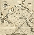 A new chart of the Mediterranean Sea - The Port of Genoa (1797).jpg 1,979 × 2,006; 604 KB
-
 A new chart of the Mediterranean Sea LOC 2012593220.jpg 22,819 × 9,546; 28.28 MB
-

-
 A new chart of the world on Mercator's projection - by William Heather - btv1b53093382c.jpg 14,897 × 11,538; 23.45 MB
-

-
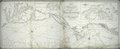
 A new general chart of the Atlantic or Western Ocean - W. Heather - btv1b531774960.jpg 10,376 × 7,970; 9.1 MB
-
 Bay of Biscay - W. Heather - btv1b53153704h.jpg 7,904 × 9,608; 7.59 MB
-
 Carta esferica del Golfo de Gascuna - W. Heather - btv1b53153713g.jpg 11,108 × 7,686; 8.01 MB
-
 Gulf of Salonique.jpg 1,459 × 1,142; 768 KB
-
 Heathers New and Improved Chart of the Isles of Scilly (8249819881).jpg 2,000 × 1,622; 2.89 MB
-
 Heathers, improved chart of the Bermudas, drawn from the best surveys (8252384803).jpg 1,248 × 2,000; 2.28 MB
-
 IAN 0554 Heather 1802 Preveza.jpg 4,545 × 3,709; 10.58 MB
-
 IAN 0943 Heather 1802 Corfu.jpg 4,664 × 3,735; 10.04 MB
-
 IAN 0944 Heather 1802 Corfu.jpg 4,639 × 3,759; 9.94 MB
-
 IAN 0945 Heather 1802 Valona.jpg 4,591 × 3,711; 9.69 MB
-
 Map of Puerto Rico (1801).jpg 2,994 × 2,099; 3.68 MB
-
 Nautical chart of the West Indies 1797.jpg 2,000 × 872; 1.35 MB
-
 A new chart of America with the harbors of New York, Boston, &c (NYPL b14915636-434394).jpg 9,588 × 3,955; 9.68 MB
-
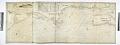
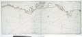
 A new chart of the coast of America from Philadelphia to Halifax Harbor (NYPL b15063057-434046).jpg 12,815 × 4,866; 15.44 MB
-

-

-

-

-

-

-

-

-
-

.jpg)
.jpg)


.jpg)
.jpg)
.jpg)
.jpg)
.jpg)
.jpg)
.jpg)
.jpg)


.jpg)
.jpg)


.jpg)

.jpg)
.jpg)
.jpg)
.jpg)
.jpg)
.jpg)
.jpg)