Category:Maps by John Speed
Jump to navigation
Jump to search
English: Maps by John Speed (1552–1629), an English cartographer and historian, the most famous map-maker of the late Tudor and early Stuart period.
Subcategories
This category has the following 33 subcategories, out of 33 total.
Media in category "Maps by John Speed"
The following 103 files are in this category, out of 103 total.
-

-
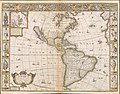 Speed-Goos America 1626 (1676) UTA.jpg 1,448 × 1,139; 1.28 MB
-
 1626 map of Tartary by John Speed.jpg 12,457 × 9,647; 26.29 MB
-
 1626 map of the Turkish Empire, newly augmented by John Speed.jpg 4,203 × 3,261; 3.08 MB
-
 1646 New Speed Kaerius.jpg 1,687 × 1,224; 1.88 MB
-
 1676 John Speed Map of Carolina - Geographicus - Carolina-speed-1676.jpg 5,000 × 3,783; 5.23 MB
-
 3.1 Canaan 1595 Speed².JPG 7,831 × 6,161; 48.77 MB
-
 Mape of Poland done into english by J. Speed, 1626.jpg 3,436 × 2,754; 4.62 MB
-
 A Mapp of Staffordshire with its Hundreds (BM 1864,1114.39).jpg 2,500 × 1,750; 1.34 MB
-
 A Mapp of the County of Hartford shire with its Hundreds (BM 1850,0223.273).jpg 2,500 × 1,738; 1.35 MB
-
 A Mapp of the County of Middlesex with its Hundreds (BM 1864,1114.37).jpg 2,500 × 1,737; 1.29 MB
-
 A Mapp of the County of Surrey (BM 1864,1114.40).jpg 2,500 × 1,750; 1.45 MB
-
 A Mapp of the County of Surrey with its divisions (BM 1864,1114.41).jpg 2,500 × 1,693; 1.32 MB
-
 A Mapp of ye County of Norfolk with its Hundreds (BM 1864,1114.38).jpg 2,500 × 1,894; 1.53 MB
-
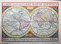
 A new and accurat map of the world - Norman B. Leventhal Map Center at the BPL.jpg 2,000 × 1,576; 3.5 MB
-

-
-

-
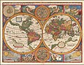
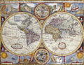 A New And Accvrat Map Of The World.png 3,491 × 2,694; 25.48 MB
-

-
 A New Mappe Of The Romane Empire.jpg 12,375 × 9,626; 26.05 MB
-
 A Newe mape of Germany - newly augmented by John Speed - btv1b10111216f (1 of 2).jpg 6,731 × 5,148; 6.53 MB
-
 A Newe Mape of Germany Newly Augmented by Iohn Speed.jpg 12,710 × 9,932; 33.11 MB
-

-
 A Newe Mape of Tartary augmented by John Speede.jpg 12,457 × 9,647; 26.29 MB
-
 Africa - DPLA - 618740d8944052ac910b33fce3d98298.jpg 1,000 × 708; 249 KB
-
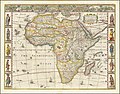 Africae, Described. The manners of their Habits and buildings newly done into English by I.S.jpg 13,124 × 10,270; 28.75 MB
-

-

-

-

-
-

-

-

-
 Ancient Gloucester from Speed's map of 1610 and Hall & Pinnell, ex Fosbroke.jpg 5,806 × 4,629; 3.23 MB
-

-

-

-
 B 1626 New Goos Speed.jpg 6,557 × 5,160; 2.95 MB
-
 B26055973D - A new map of East India.jpg 6,768 × 5,302; 8.89 MB
-

-
 Babilon. A New Mappe Of The Romane Empire (cropped).jpg 2,556 × 1,803; 1.07 MB
-
-
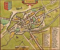
 Bodleian Libraries, Buckingham Both Shyre and Shiretowne describ.jpg 992 × 672; 155 KB
-
 Bodleian Libraries, Oxford city plan.jpg 1,000 × 675; 172 KB
-
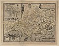
 Bodleian Libraries, Oxfordshire described.jpg 1,000 × 675; 189 KB
-
 Bodleian Libraries, Oxfordshire, with inset map of Oxford.jpg 1,000 × 687; 142 KB
-
 Bodleian Libraries, Worth Forest (north central Sussex).jpg 1,000 × 675; 155 KB
-
 Caernarvon... - btv1b53010591k.jpg 7,729 × 6,619; 7.73 MB
-
 Canaan... Begun - by Mr John More ; continued and finished by John Speede - btv1b8491520b.jpg 9,175 × 7,315; 10.87 MB
-
 Carolina Vintage Map.JPG 1,600 × 1,096; 503 KB
-
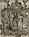 Cartouche in a Holy Land map by John Speed, showing Adam and Eve.jpg 771 × 984; 191 KB
-
 Cornwall (BM 1893,0803.120).jpg 2,500 × 976; 625 KB
-
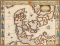 John Speed - The Kingdome of Denmarke.png 1,894 × 1,453; 7.01 MB
-
 Dorsetshyre... - Jodocus Hondius caelavit - btv1b53056397t (1 of 2).jpg 6,880 × 5,360; 6.65 MB
-
 Engraved map of Chichester from John Speed's 1610 map of Sussex.jpg 1,084 × 809; 751 KB
-

-

-
 Glocestershire... - Performed by John Speede - btv1b53056985s (1 of 2).jpg 6,448 × 4,896; 5.69 MB
-

-
 Hartforde - btv1b8445048j.jpg 2,449 × 2,212; 880 KB
-
 Hundreds in Essex (BM 1864,1114.35).jpg 2,500 × 1,763; 1.36 MB
-
 Ipswich (BM 1868,0822.5932).jpg 1,838 × 1,525; 869 KB
-
 Italia Newly augmented by I. Speed.jpg 12,652 × 9,822; 20.92 MB
-
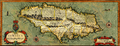 Jamaica 1676 (John Speed).png 5,935 × 2,268; 16.37 MB
-
 John Speed - Map of Greece.jpg 12,456 × 9,796; 26.3 MB
-
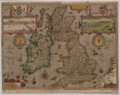 John Speed - The Kingdome of Great Britaine and Ireland.png 6,232 × 4,946; 54.59 MB
-
 John Speed-Aycliffe-and-area.png 1,024 × 801; 1.21 MB
-
 John Speed. The Turkish Empire. Newly Augmented by John Speed. 1626.jpg 1,543 × 1,200; 2.78 MB
-
 London (BM 1874,0808.2162).jpg 2,356 × 1,542; 1.35 MB
-

-
 Map of Greece by John Speed.jpg 12,637 × 9,961; 27.31 MB
-
 Map of Seventeen Provinces of Low Germanie (Zeventien Provincien der Nederlanden) 1626.jpg 10,000 × 7,836; 20.09 MB
-

-

-

-

-

-

-
 Ship and Sea monster in China sea, detail by Speed.jpg 2,201 × 1,594; 772 KB
-
 Somers Isles Map - John Speed 1676.jpg 2,744 × 1,781; 2.86 MB
-
 Somers Isles Map by John Speed 1676 - Parish of St George.jpg 769 × 966; 468 KB
-
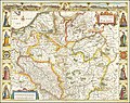
 Speed's Map of Lancashire, 1623.jpg 2,560 × 1,920; 1.29 MB
-
 Speede Poland.jpg 1,600 × 1,271; 2.83 MB
-
 Stamford map.jpg 1,892 × 1,571; 1.84 MB
-

-

-
 The Kingdome of China newly augmented by I.S. 1626.jpg 12,701 × 9,978; 29.59 MB
-
 The Kingdome of England (BM 1870,0514.2828).jpg 2,500 × 1,786; 963 KB
-
 The Kingdome of Irland (BM 1870,0514.2830.+).jpg 2,500 × 1,945; 1.25 MB
-
 The Kingdome of Persia with the cheef citties and Habites described by John Speede.jpg 12,776 × 10,013; 28.51 MB
-

-
 The Turkish Empire. Newly Augmented by John Speed 1626.jpg 1,600 × 1,236; 1.1 MB
-
 The Turkish Empire. Newly Augmented by John Speed. 1626.jpg 12,355 × 9,526; 27.79 MB
-
 Wales - Performed by John Speed - btv1b53056612d (1 of 2).jpg 6,872 × 5,304; 6.96 MB
-
 Wales - Performed by John Speed - btv1b532254101 (2 of 3).jpg 6,257 × 4,830; 7.33 MB
-

-

-
 Worcester Castle 1610.jpg 588 × 369; 67 KB
-
 York Shire - Performed by Iohn Speed - btv1b530563128 (1 of 2).jpg 6,784 × 5,304; 6.53 MB
-
 York Shire - Performed by Iohn Speed - btv1b532253990 (2 of 3).jpg 5,990 × 4,576; 6.88 MB
-
 ZXVII Speed K.jpg 867 × 620; 904 KB
.jpg)
_UTA.jpg)


.jpg)
.jpg)
.jpg)
.jpg)
.jpg)
.jpg)

.jpg)

.jpg)

.jpg)

.jpg)

.jpg)


.jpg)
.jpg)
.jpg)
.jpg)


.jpg)
.jpg)


.jpg)


.jpg)


.jpg)


.jpg)
.jpg)


.jpg)
.jpg)


.jpg)
.jpg)

_1626.jpg)

o_1605_-_Performed_by_John_Speede_-_btv1b53056520j_(1_of_2).jpg)
o_1605_-_Performed_by_John_Speede_-_btv1b532253810_(2_of_3).jpg)
.jpg)
.jpg)
.jpg)


.jpg)
.jpg)

.jpg)
.jpg)


.jpg)
.jpg)
.jpg)
.jpg)

.jpg)
.jpg)

.jpg)
.jpg)
.png)