Category:Maps by Henry Wellge
Jump to navigation
Jump to search
Subcategories
This category has the following 2 subcategories, out of 2 total.
S
Media in category "Maps by Henry Wellge"
The following 22 files are in this category, out of 22 total.
-
 Anniston Alabama map 1887.png 482 × 336; 148 KB
-
 MT Billings 1904.jpg 9,056 × 5,632; 42.92 MB
-
 Coaticook - 1881.jpg 1,158 × 745; 518 KB
-
 Bridgescolumbus.jpg 707 × 446; 168 KB
-
 Old map-Denison-1886.jpg 8,113 × 5,765; 10.51 MB
-
 CO Denver 1889.jpg 1,024 × 656; 644 KB
-
 Perspective map of the city of Denver, Colo. 1889. LOC 75693132.jpg 13,152 × 8,432; 24.25 MB
-
 Old map-Fort Worth-1886.jpg 10,000 × 7,785; 18.73 MB
-
 Old map-Fort Worth-1891.jpg 9,909 × 5,974; 14.64 MB
-
 San Antonio Light Bird's Eye View Map of San Antonio, Texas December 1891 UTA.jpg 3,150 × 2,136; 3.32 MB
-
 Wellge Perspective Map of Fort Worth, Tex. 1891 UTA.jpg 9,000 × 5,326; 15.61 MB
-
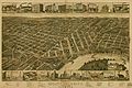
 Old map-Greenville-1886.jpg 7,467 × 5,184; 16.9 MB
-
 Old map-Honey Grove-1886.jpg 6,656 × 4,765; 7.12 MB
-
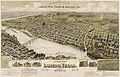 Old map-Laredo-1892.jpg 10,254 × 6,618; 13.53 MB
-
 Montgomery Alabama 1887 map.jpg 11,232 × 7,488; 18.49 MB
-
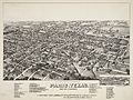 Old map-Paris-1885.jpg 7,154 × 5,337; 10.09 MB
-
 Selma Alabama map 1887.jpg 10,592 × 6,624; 14.14 MB
-
 Sherbrooke 1881.jpg 7,416 × 6,160; 10.67 MB
-
 Sherbrooke 1881.PNG 2,567 × 1,942; 4.87 MB
-
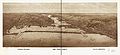 The twin ports-Superior, Wisconsin, Duluth, Minnesota.jpg 4,019 × 1,848; 3.22 MB
-
 Old map-Texarkana-1888.jpg 8,246 × 4,813; 11.75 MB
-
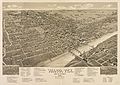 Old map-Waco-1886.jpg 9,796 × 6,920; 16.33 MB


